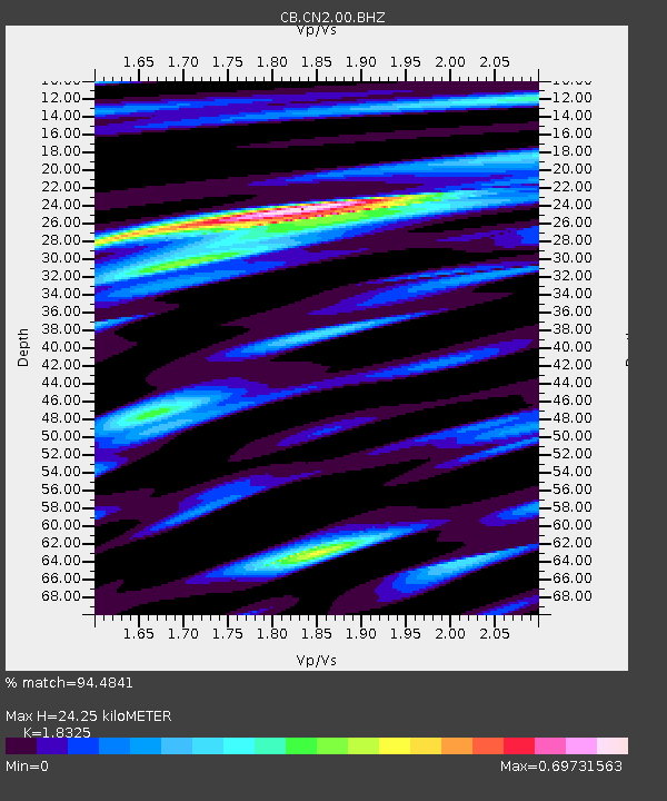
CN2 Changchun,Jilin Province - Earthquake Result Viewer

Earthquake location: Southern Sumatra, Indonesia
Earthquake latitude/longitude: -2.1/100.7
Earthquake time(UTC): 2016/06/01 (153) 22:56:00 GMT
Earthquake Depth: 50 km
Earthquake Magnitude: 6.6 MWW, 6.4 MWB, 6.6 MWC, 6.7 MWC
Earthquake Catalog/Contributor: NEIC PDE/NEIC COMCAT
Network: CB China National Seismic Network
Station: CN2 Changchun,Jilin Province
Lat/Lon: 43.48 N/125.26 E
Elevation: 223 m
Distance: 50.5 deg
Az: 23.13 deg
Baz: 212.635 deg
Ray Param: 0.0679087
Estimated Moho Depth: 24.25 km
Estimated Crust Vp/Vs: 1.83
Assumed Crust Vp: 6.459 km/s
Estimated Crust Vs: 3.525 km/s
Estimated Crust Poisson's Ratio: 0.29
Radial Match: 94.4841 %
Radial Bump: 280
Transverse Match: 91.10459 %
Transverse Bump: 332
SOD ConfigId: 7422571
Insert Time: 2019-04-22 17:34:54.227 +0000
GWidth: 2.5
Max Bumps: 400
Tol: 0.001

Signal To Noise

ChannelStoNSTALTA
CB:CN2:00:BHZ:20160601T23:04:23.060013Z29.3145853.6695499E-61.251783E-7
CB:CN2:00:BHN:20160601T23:04:23.060013Z21.5582071.4853969E-66.8901684E-8
CB:CN2:00:BHE:20160601T23:04:23.060013Z12.4387058.884384E-77.142531E-8
Arrivals
Ps3.3 SECOND
PpPs10 SECOND
PsPs/PpSs13 SECOND