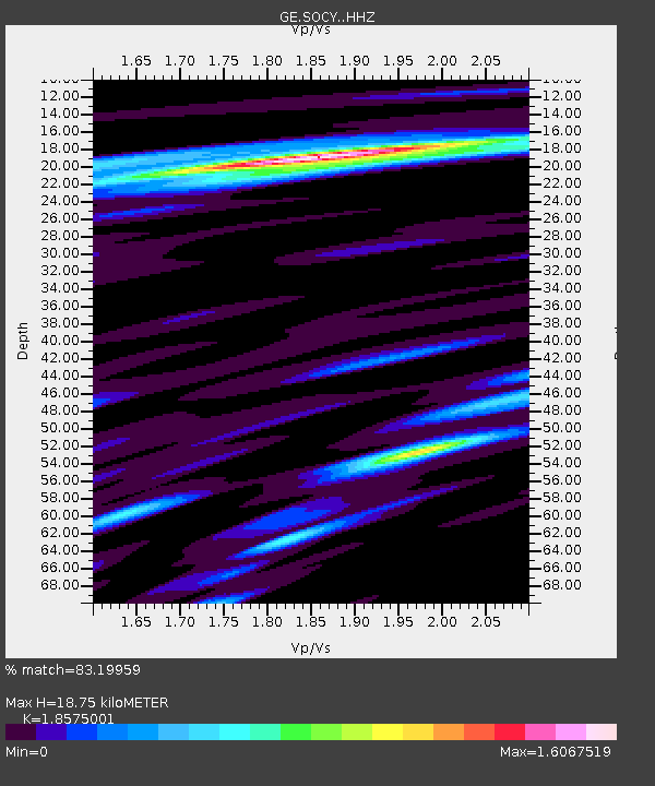
SOCY GEOFON Station Socotra, Yemen - Earthquake Result Viewer

Earthquake location: Southern Sumatra, Indonesia
Earthquake latitude/longitude: -2.1/100.7
Earthquake time(UTC): 2016/06/01 (153) 22:56:00 GMT
Earthquake Depth: 50 km
Earthquake Magnitude: 6.6 MWW, 6.4 MWB, 6.6 MWC, 6.7 MWC
Earthquake Catalog/Contributor: NEIC PDE/NEIC COMCAT
Network: GE GEOFON
Station: SOCY GEOFON Station Socotra, Yemen
Lat/Lon: 12.19 N/53.99 E
Elevation: 804 m
Distance: 48.5 deg
Az: 288.202 deg
Baz: 103.848 deg
Ray Param: 0.06919266
Estimated Moho Depth: 18.75 km
Estimated Crust Vp/Vs: 1.86
Assumed Crust Vp: 4.662 km/s
Estimated Crust Vs: 2.51 km/s
Estimated Crust Poisson's Ratio: 0.30
Radial Match: 83.19959 %
Radial Bump: 400
Transverse Match: 76.31568 %
Transverse Bump: 400
SOD ConfigId: 7422571
Insert Time: 2019-04-22 17:35:31.177 +0000
GWidth: 2.5
Max Bumps: 400
Tol: 0.001

Signal To Noise

ChannelStoNSTALTA
GE:SOCY: :HHZ:20160601T23:04:08.017991Z3.85166881.8090996E-64.696924E-7
GE:SOCY: :HHN:20160601T23:04:08.017991Z2.31959926.902587E-72.9757672E-7
GE:SOCY: :HHE:20160601T23:04:08.017991Z2.87243911.0841953E-63.7744763E-7
Arrivals
Ps3.5 SECOND
PpPs11 SECOND
PsPs/PpSs15 SECOND