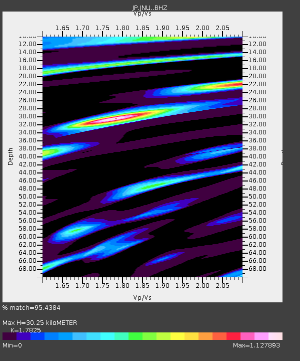
JNU Oita Nakatsue - Earthquake Result Viewer

Earthquake location: Southern Sumatra, Indonesia
Earthquake latitude/longitude: -2.1/100.7
Earthquake time(UTC): 2016/06/01 (153) 22:56:00 GMT
Earthquake Depth: 50 km
Earthquake Magnitude: 6.6 MWW, 6.4 MWB, 6.6 MWC, 6.7 MWC
Earthquake Catalog/Contributor: NEIC PDE/NEIC COMCAT
Network: JP Japan Meteorological Agency Seismic Network
Station: JNU Oita Nakatsue
Lat/Lon: 33.12 N/130.88 E
Elevation: 540 m
Distance: 45.2 deg
Az: 36.538 deg
Baz: 225.155 deg
Ray Param: 0.07131592
Estimated Moho Depth: 30.25 km
Estimated Crust Vp/Vs: 1.78
Assumed Crust Vp: 6.468 km/s
Estimated Crust Vs: 3.628 km/s
Estimated Crust Poisson's Ratio: 0.27
Radial Match: 95.4384 %
Radial Bump: 316
Transverse Match: 88.8814 %
Transverse Bump: 400
SOD ConfigId: 7422571
Insert Time: 2019-04-22 17:36:07.516 +0000
GWidth: 2.5
Max Bumps: 400
Tol: 0.001

Signal To Noise

ChannelStoNSTALTA
JP:JNU: :BHZ:20160601T23:03:42.199998Z39.296438.742758E-62.2248224E-7
JP:JNU: :BHN:20160601T23:03:42.199998Z13.8803952.9908363E-62.1547199E-7
JP:JNU: :BHE:20160601T23:03:42.199998Z13.7937142.5343525E-61.8373241E-7
Arrivals
Ps3.9 SECOND
PpPs12 SECOND
PsPs/PpSs16 SECOND