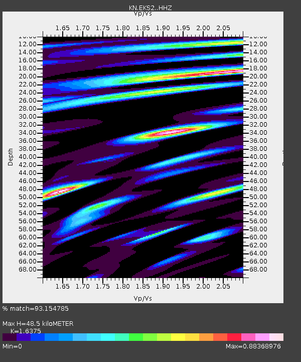
EKS2 KN.EKS2 - Earthquake Result Viewer
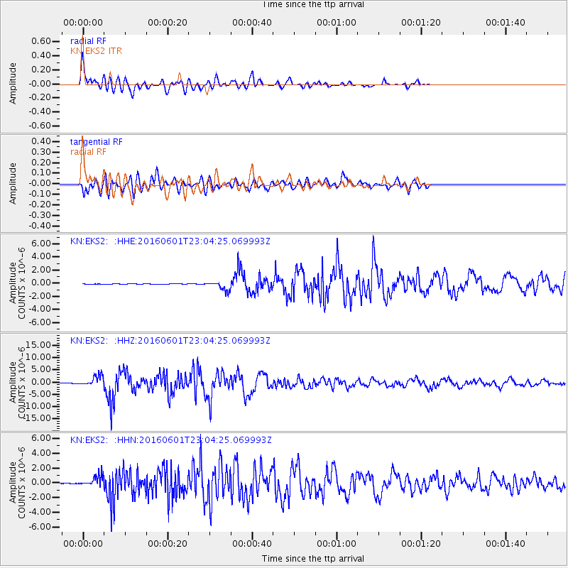
Earthquake location: Southern Sumatra, Indonesia
Earthquake latitude/longitude: -2.1/100.7
Earthquake time(UTC): 2016/06/01 (153) 22:56:00 GMT
Earthquake Depth: 50 km
Earthquake Magnitude: 6.6 MWW, 6.4 MWB, 6.6 MWC, 6.7 MWC
Earthquake Catalog/Contributor: NEIC PDE/NEIC COMCAT
Network: KN Kyrgyz Seismic Telemetry Network
Station: EKS2 KN.EKS2
Lat/Lon: 42.66 N/73.78 E
Elevation: 1360 m
Distance: 50.7 deg
Az: 334.472 deg
Baz: 144.279 deg
Ray Param: 0.06773353
Estimated Moho Depth: 48.5 km
Estimated Crust Vp/Vs: 1.64
Assumed Crust Vp: 6.316 km/s
Estimated Crust Vs: 3.857 km/s
Estimated Crust Poisson's Ratio: 0.20
Radial Match: 93.154785 %
Radial Bump: 400
Transverse Match: 84.45017 %
Transverse Bump: 400
SOD ConfigId: 7422571
Insert Time: 2019-04-22 17:36:17.474 +0000
GWidth: 2.5
Max Bumps: 400
Tol: 0.001

Signal To Noise

ChannelStoNSTALTA
KN:EKS2: :HHZ:20160601T23:04:25.069993Z65.2496952.2538993E-63.4542676E-8
KN:EKS2: :HHN:20160601T23:04:25.069993Z21.60417.6557603E-73.543661E-8
KN:EKS2: :HHE:20160601T23:04:25.069993Z22.505956.9638776E-73.0942385E-8
Arrivals
Ps5.2 SECOND
PpPs19 SECOND
PsPs/PpSs24 SECOND