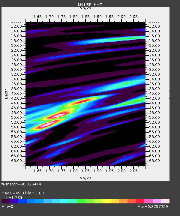
USP KN.USP - Earthquake Result Viewer
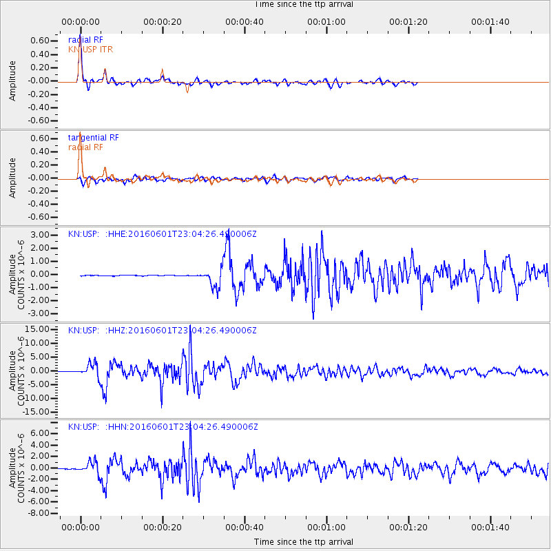
Earthquake location: Southern Sumatra, Indonesia
Earthquake latitude/longitude: -2.1/100.7
Earthquake time(UTC): 2016/06/01 (153) 22:56:00 GMT
Earthquake Depth: 50 km
Earthquake Magnitude: 6.6 MWW, 6.4 MWB, 6.6 MWC, 6.7 MWC
Earthquake Catalog/Contributor: NEIC PDE/NEIC COMCAT
Network: KN Kyrgyz Seismic Telemetry Network
Station: USP KN.USP
Lat/Lon: 43.27 N/74.50 E
Elevation: 740 m
Distance: 50.9 deg
Az: 335.481 deg
Baz: 145.407 deg
Ray Param: 0.06761578
Estimated Moho Depth: 49.0 km
Estimated Crust Vp/Vs: 1.74
Assumed Crust Vp: 6.306 km/s
Estimated Crust Vs: 3.635 km/s
Estimated Crust Poisson's Ratio: 0.25
Radial Match: 96.025444 %
Radial Bump: 283
Transverse Match: 88.58053 %
Transverse Bump: 400
SOD ConfigId: 7422571
Insert Time: 2019-04-22 17:36:23.301 +0000
GWidth: 2.5
Max Bumps: 400
Tol: 0.001

Signal To Noise

ChannelStoNSTALTA
KN:USP: :HHZ:20160601T23:04:26.490006Z80.31092.5042286E-63.118168E-8
KN:USP: :HHN:20160601T23:04:26.490006Z27.3384231.0857774E-63.9716166E-8
KN:USP: :HHE:20160601T23:04:26.490006Z28.699027.307266E-72.5461725E-8
Arrivals
Ps6.0 SECOND
PpPs20 SECOND
PsPs/PpSs26 SECOND