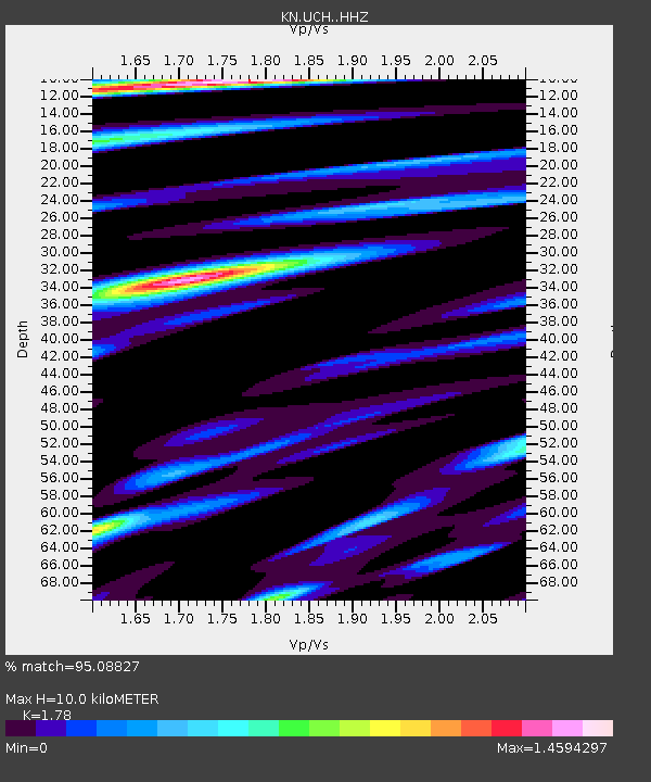
UCH - - Earthquake Result Viewer
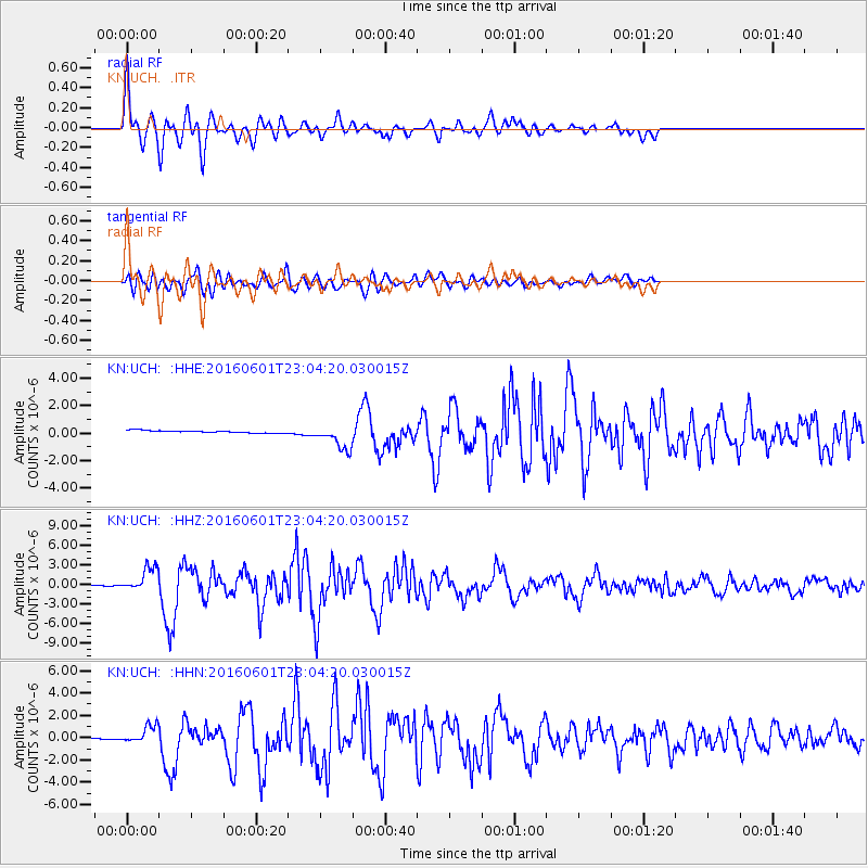
Earthquake location: Southern Sumatra, Indonesia
Earthquake latitude/longitude: -2.1/100.7
Earthquake time(UTC): 2016/06/01 (153) 22:56:00 GMT
Earthquake Depth: 50 km
Earthquake Magnitude: 6.6 MWW, 6.4 MWB, 6.6 MWC, 6.7 MWC
Earthquake Catalog/Contributor: NEIC PDE/NEIC COMCAT
Network: KN Kyrgyz Seismic Telemetry Network
Station: UCH -
Lat/Lon: 42.23 N/74.51 E
Elevation: 3850 m
Distance: 50.1 deg
Az: 334.723 deg
Baz: 144.934 deg
Ray Param: 0.06817721
Estimated Moho Depth: 10.0 km
Estimated Crust Vp/Vs: 1.78
Assumed Crust Vp: 6.306 km/s
Estimated Crust Vs: 3.543 km/s
Estimated Crust Poisson's Ratio: 0.27
Radial Match: 95.08827 %
Radial Bump: 400
Transverse Match: 85.11998 %
Transverse Bump: 400
SOD ConfigId: 7422571
Insert Time: 2019-04-22 17:36:23.570 +0000
GWidth: 2.5
Max Bumps: 400
Tol: 0.001

Signal To Noise

ChannelStoNSTALTA
KN:UCH: :HHZ:20160601T23:04:20.030015Z59.145181.8716773E-63.1645474E-8
KN:UCH: :HHN:20160601T23:04:20.030015Z8.2984677.1249906E-78.5859114E-8
KN:UCH: :HHE:20160601T23:04:20.030015Z10.932749.121448E-78.3432404E-8
Arrivals
Ps1.3 SECOND
PpPs4.2 SECOND
PsPs/PpSs5.5 SECOND