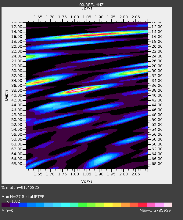
DRE Drenchia - Earthquake Result Viewer

Earthquake location: Southern Sumatra, Indonesia
Earthquake latitude/longitude: -2.1/100.7
Earthquake time(UTC): 2016/06/01 (153) 22:56:00 GMT
Earthquake Depth: 50 km
Earthquake Magnitude: 6.6 MWW, 6.4 MWB, 6.6 MWC, 6.7 MWC
Earthquake Catalog/Contributor: NEIC PDE/NEIC COMCAT
Network: OX North-East Italy Seismic Network
Station: DRE Drenchia
Lat/Lon: 46.17 N/13.65 E
Elevation: 810 m
Distance: 89.4 deg
Az: 316.053 deg
Baz: 93.583 deg
Ray Param: 0.041777812
Estimated Moho Depth: 37.5 km
Estimated Crust Vp/Vs: 1.82
Assumed Crust Vp: 6.35 km/s
Estimated Crust Vs: 3.489 km/s
Estimated Crust Poisson's Ratio: 0.28
Radial Match: 91.40823 %
Radial Bump: 400
Transverse Match: 90.20738 %
Transverse Bump: 400
SOD ConfigId: 7422571
Insert Time: 2019-04-22 17:37:28.286 +0000
GWidth: 2.5
Max Bumps: 400
Tol: 0.001

Signal To Noise

ChannelStoNSTALTA
OX:DRE: :HHZ:20160601T23:08:21.03801Z15.4392354.3145468E-72.794534E-8
OX:DRE: :HHN:20160601T23:08:21.03801Z3.4779441.1153344E-73.2068787E-8
OX:DRE: :HHE:20160601T23:08:21.03801Z6.03632071.890462E-73.1318116E-8
Arrivals
Ps4.9 SECOND
PpPs16 SECOND
PsPs/PpSs21 SECOND