You are here: Home > Network List > TA - USArray Transportable Network (new EarthScope stations) Stations List
> Station A21K Barrow, AK, USA > Earthquake Result Viewer
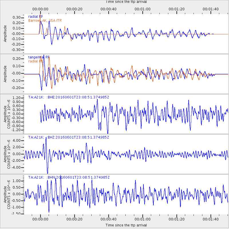
A21K Barrow, AK, USA - Earthquake Result Viewer
*The percent match for this event was below the threshold and hence no stack was calculated.
| Earthquake location: |
Southern Sumatra, Indonesia |
| Earthquake latitude/longitude: |
-2.1/100.7 |
| Earthquake time(UTC): |
2016/06/01 (153) 22:56:00 GMT |
| Earthquake Depth: |
50 km |
| Earthquake Magnitude: |
6.6 MWW, 6.4 MWB, 6.6 MWC, 6.7 MWC |
| Earthquake Catalog/Contributor: |
NEIC PDE/NEIC COMCAT |
|
| Network: |
TA USArray Transportable Network (new EarthScope stations) |
| Station: |
A21K Barrow, AK, USA |
| Lat/Lon: |
71.32 N/156.62 W |
| Elevation: |
577 m |
|
| Distance: |
96.0 deg |
| Az: |
18.423 deg |
| Baz: |
281.4 deg |
| Ray Param: |
$rayparam |
*The percent match for this event was below the threshold and hence was not used in the summary stack. |
|
| Radial Match: |
76.537575 % |
| Radial Bump: |
400 |
| Transverse Match: |
76.54429 % |
| Transverse Bump: |
400 |
| SOD ConfigId: |
7422571 |
| Insert Time: |
2019-04-22 17:38:08.178 +0000 |
| GWidth: |
2.5 |
| Max Bumps: |
400 |
| Tol: |
0.001 |
|
Signal To Noise
| Channel | StoN | STA | LTA |
| TA:A21K: :BHZ:20160601T23:08:51.374985Z | 4.6057453 | 2.4802578E-6 | 5.3851386E-7 |
| TA:A21K: :BHN:20160601T23:08:51.374985Z | 1.8927488 | 4.747543E-7 | 2.5082795E-7 |
| TA:A21K: :BHE:20160601T23:08:51.374985Z | 2.0302467 | 5.621622E-7 | 2.7689353E-7 |
| Arrivals |
| Ps | |
| PpPs | |
| PsPs/PpSs | |


