You are here: Home > Network List > TA - USArray Transportable Network (new EarthScope stations) Stations List
> Station O17K Koliganek, Bristol Bay, AK, USA > Earthquake Result Viewer
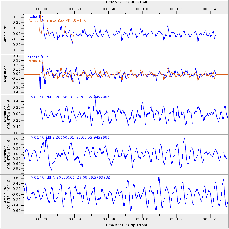
O17K Koliganek, Bristol Bay, AK, USA - Earthquake Result Viewer
*The percent match for this event was below the threshold and hence no stack was calculated.
| Earthquake location: |
Southern Sumatra, Indonesia |
| Earthquake latitude/longitude: |
-2.1/100.7 |
| Earthquake time(UTC): |
2016/06/01 (153) 22:56:00 GMT |
| Earthquake Depth: |
50 km |
| Earthquake Magnitude: |
6.6 MWW, 6.4 MWB, 6.6 MWC, 6.7 MWC |
| Earthquake Catalog/Contributor: |
NEIC PDE/NEIC COMCAT |
|
| Network: |
TA USArray Transportable Network (new EarthScope stations) |
| Station: |
O17K Koliganek, Bristol Bay, AK, USA |
| Lat/Lon: |
59.77 N/157.09 W |
| Elevation: |
156 m |
|
| Distance: |
98.0 deg |
| Az: |
29.951 deg |
| Baz: |
279.555 deg |
| Ray Param: |
$rayparam |
*The percent match for this event was below the threshold and hence was not used in the summary stack. |
|
| Radial Match: |
63.53683 % |
| Radial Bump: |
400 |
| Transverse Match: |
67.827126 % |
| Transverse Bump: |
400 |
| SOD ConfigId: |
7422571 |
| Insert Time: |
2019-04-22 17:38:09.080 +0000 |
| GWidth: |
2.5 |
| Max Bumps: |
400 |
| Tol: |
0.001 |
|
Signal To Noise
| Channel | StoN | STA | LTA |
| TA:O17K: :BHZ:20160601T23:08:59.949998Z | 2.774943 | 5.664479E-7 | 2.0412956E-7 |
| TA:O17K: :BHN:20160601T23:08:59.949998Z | 0.70232385 | 1.3661871E-7 | 1.945238E-7 |
| TA:O17K: :BHE:20160601T23:08:59.949998Z | 2.337512 | 2.7827892E-7 | 1.1904919E-7 |
| Arrivals |
| Ps | |
| PpPs | |
| PsPs/PpSs | |


