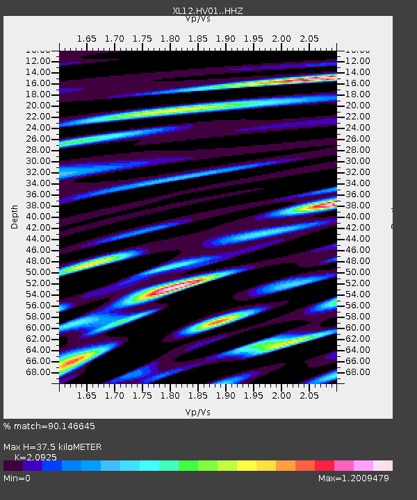
HV01 HV01 - Earthquake Result Viewer

Earthquake location: Southern Sumatra, Indonesia
Earthquake latitude/longitude: -2.1/100.7
Earthquake time(UTC): 2016/06/01 (153) 22:56:00 GMT
Earthquake Depth: 50 km
Earthquake Magnitude: 6.6 MWW, 6.4 MWB, 6.6 MWC, 6.7 MWC
Earthquake Catalog/Contributor: NEIC PDE/NEIC COMCAT
Network: XL Hangay Dome, Mongolia
Station: HV01 HV01
Lat/Lon: 51.39 N/99.33 E
Elevation: 1539 m
Distance: 53.3 deg
Az: 358.956 deg
Baz: 178.334 deg
Ray Param: 0.0660691
Estimated Moho Depth: 37.5 km
Estimated Crust Vp/Vs: 2.09
Assumed Crust Vp: 6.622 km/s
Estimated Crust Vs: 3.165 km/s
Estimated Crust Poisson's Ratio: 0.35
Radial Match: 90.146645 %
Radial Bump: 400
Transverse Match: 89.819405 %
Transverse Bump: 400
SOD ConfigId: 7422571
Insert Time: 2019-04-22 17:38:32.395 +0000
GWidth: 2.5
Max Bumps: 400
Tol: 0.001

Signal To Noise

ChannelStoNSTALTA
XL:HV01: :HHZ:20160601T23:04:44.109971Z149.520264.4418807E-62.9707552E-8
XL:HV01: :HHN:20160601T23:04:44.109971Z50.031431.7352538E-63.4683275E-8
XL:HV01: :HHE:20160601T23:04:44.109971Z21.0883581.0265098E-64.8676608E-8
Arrivals
Ps6.5 SECOND
PpPs17 SECOND
PsPs/PpSs23 SECOND