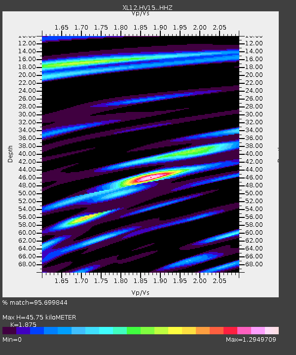
HV15 HV15 - Earthquake Result Viewer

Earthquake location: Southern Sumatra, Indonesia
Earthquake latitude/longitude: -2.1/100.7
Earthquake time(UTC): 2016/06/01 (153) 22:56:00 GMT
Earthquake Depth: 50 km
Earthquake Magnitude: 6.6 MWW, 6.4 MWB, 6.6 MWC, 6.7 MWC
Earthquake Catalog/Contributor: NEIC PDE/NEIC COMCAT
Network: XL Hangay Dome, Mongolia
Station: HV15 HV15
Lat/Lon: 50.11 N/100.06 E
Elevation: 1569 m
Distance: 52.0 deg
Az: 359.504 deg
Baz: 179.23 deg
Ray Param: 0.06691302
Estimated Moho Depth: 45.75 km
Estimated Crust Vp/Vs: 1.88
Assumed Crust Vp: 6.419 km/s
Estimated Crust Vs: 3.424 km/s
Estimated Crust Poisson's Ratio: 0.30
Radial Match: 95.699844 %
Radial Bump: 400
Transverse Match: 89.748405 %
Transverse Bump: 400
SOD ConfigId: 7422571
Insert Time: 2019-04-22 17:38:40.242 +0000
GWidth: 2.5
Max Bumps: 400
Tol: 0.001

Signal To Noise

ChannelStoNSTALTA
XL:HV15: :HHZ:20160601T23:04:34.598984Z142.333794.0686436E-62.8585228E-8
XL:HV15: :HHN:20160601T23:04:34.598984Z92.377721.9714169E-62.1340826E-8
XL:HV15: :HHE:20160601T23:04:34.598984Z10.8420251.8256006E-71.683819E-8
Arrivals
Ps6.6 SECOND
PpPs19 SECOND
PsPs/PpSs26 SECOND