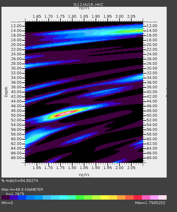
HV19 HV19 - Earthquake Result Viewer

Earthquake location: Southern Sumatra, Indonesia
Earthquake latitude/longitude: -2.1/100.7
Earthquake time(UTC): 2016/06/01 (153) 22:56:00 GMT
Earthquake Depth: 50 km
Earthquake Magnitude: 6.6 MWW, 6.4 MWB, 6.6 MWC, 6.7 MWC
Earthquake Catalog/Contributor: NEIC PDE/NEIC COMCAT
Network: XL Hangay Dome, Mongolia
Station: HV19 HV19
Lat/Lon: 50.98 N/100.73 E
Elevation: 1683 m
Distance: 52.9 deg
Az: 0.049 deg
Baz: 180.077 deg
Ray Param: 0.06635197
Estimated Moho Depth: 49.0 km
Estimated Crust Vp/Vs: 1.77
Assumed Crust Vp: 6.419 km/s
Estimated Crust Vs: 3.632 km/s
Estimated Crust Poisson's Ratio: 0.26
Radial Match: 94.98274 %
Radial Bump: 270
Transverse Match: 83.6477 %
Transverse Bump: 400
SOD ConfigId: 7422571
Insert Time: 2019-04-22 17:38:41.792 +0000
GWidth: 2.5
Max Bumps: 400
Tol: 0.001

Signal To Noise

ChannelStoNSTALTA
XL:HV19: :HHZ:20160601T23:04:40.999985Z87.995913.043958E-63.4592038E-8
XL:HV19: :HHN:20160601T23:04:40.999985Z57.922791.5176411E-62.6201104E-8
XL:HV19: :HHE:20160601T23:04:40.999985Z12.8808723.0873701E-72.3968642E-8
Arrivals
Ps6.2 SECOND
PpPs20 SECOND
PsPs/PpSs26 SECOND