You are here: Home > Network List > 7A - Mid-Atlantic Geophysical Integrative Collaboration Stations List
> Station CAKE Sugar Grove, West Virginia USA > Earthquake Result Viewer
CAKE Sugar Grove, West Virginia USA - Earthquake Result Viewer
| Earthquake location: |
Off Coast Of Jalisco, Mexico |
| Earthquake latitude/longitude: |
18.0/-105.9 |
| Earthquake time(UTC): |
2016/06/02 (154) 02:23:06 GMT |
| Earthquake Depth: |
10 km |
| Earthquake Magnitude: |
5.8 MWW, 5.8 MWC |
| Earthquake Catalog/Contributor: |
NEIC PDE/NEIC COMCAT |
|
| Network: |
7A Mid-Atlantic Geophysical Integrative Collaboration |
| Station: |
CAKE Sugar Grove, West Virginia USA |
| Lat/Lon: |
38.52 N/79.30 W |
| Elevation: |
640 m |
|
| Distance: |
30.9 deg |
| Az: |
43.131 deg |
| Baz: |
236.026 deg |
| Ray Param: |
0.07922126 |
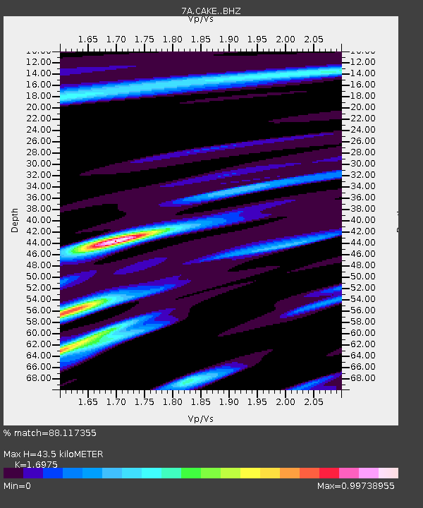
| Estimated Moho Depth: |
43.5 km |
| Estimated Crust Vp/Vs: |
1.70 |
| Assumed Crust Vp: |
6.159 km/s |
| Estimated Crust Vs: |
3.628 km/s |
| Estimated Crust Poisson's Ratio: |
0.23 |
|
| Radial Match: |
88.117355 % |
| Radial Bump: |
272 |
| Transverse Match: |
67.52506 % |
| Transverse Bump: |
400 |
| SOD ConfigId: |
7422571 |
| Insert Time: |
2019-04-22 17:40:43.419 +0000 |
| GWidth: |
2.5 |
| Max Bumps: |
400 |
| Tol: |
0.001 |
|

Signal To Noise
| Channel | StoN | STA | LTA |
| 7A:CAKE: :BHZ:20160602T02:28:51.435011Z | 4.6203117 | 5.196843E-7 | 1.1247819E-7 |
| 7A:CAKE: :BHN:20160602T02:28:51.435011Z | 2.7680097 | 2.4649236E-7 | 8.9050396E-8 |
| 7A:CAKE: :BHE:20160602T02:28:51.435011Z | 3.5610194 | 2.9823778E-7 | 8.375067E-8 |
| Arrivals |
| Ps | 5.3 SECOND |
| PpPs | 18 SECOND |
| PsPs/PpSs | 23 SECOND |


