You are here: Home > Network List > US - United States National Seismic Network Stations List
> Station DUG Dugway, Tooele County, Utah, USA > Earthquake Result Viewer
DUG Dugway, Tooele County, Utah, USA - Earthquake Result Viewer

| Earthquake location: |
Southwestern Siberia, Russia |
| Earthquake latitude/longitude: |
50.2/87.7 |
| Earthquake time(UTC): |
2003/10/01 (274) 01:03:25 GMT |
| Earthquake Depth: |
10 km |
| Earthquake Magnitude: |
6.3 MB, 7.1 MS, 6.7 MW, 6.7 MW |
| Earthquake Catalog/Contributor: |
WHDF/NEIC |
|
| Network: |
US United States National Seismic Network |
| Station: |
DUG Dugway, Tooele County, Utah, USA |
| Lat/Lon: |
40.19 N/112.81 W |
| Elevation: |
1477 m |
|
| Distance: |
88.2 deg |
| Az: |
15.594 deg |
| Baz: |
346.969 deg |
| Ray Param: |
0.04277761 |
| Estimated Moho Depth: |
30.25 km |
| Estimated Crust Vp/Vs: |
1.91 |
| Assumed Crust Vp: |
6.276 km/s |
| Estimated Crust Vs: |
3.286 km/s |
| Estimated Crust Poisson's Ratio: |
0.31 |
|
| Radial Match: |
95.055855 % |
| Radial Bump: |
400 |
| Transverse Match: |
89.17271 % |
| Transverse Bump: |
400 |
| SOD ConfigId: |
110177 |
| Insert Time: |
2010-03-05 04:09:54.386 +0000 |
| GWidth: |
2.5 |
| Max Bumps: |
400 |
| Tol: |
0.001 |
|
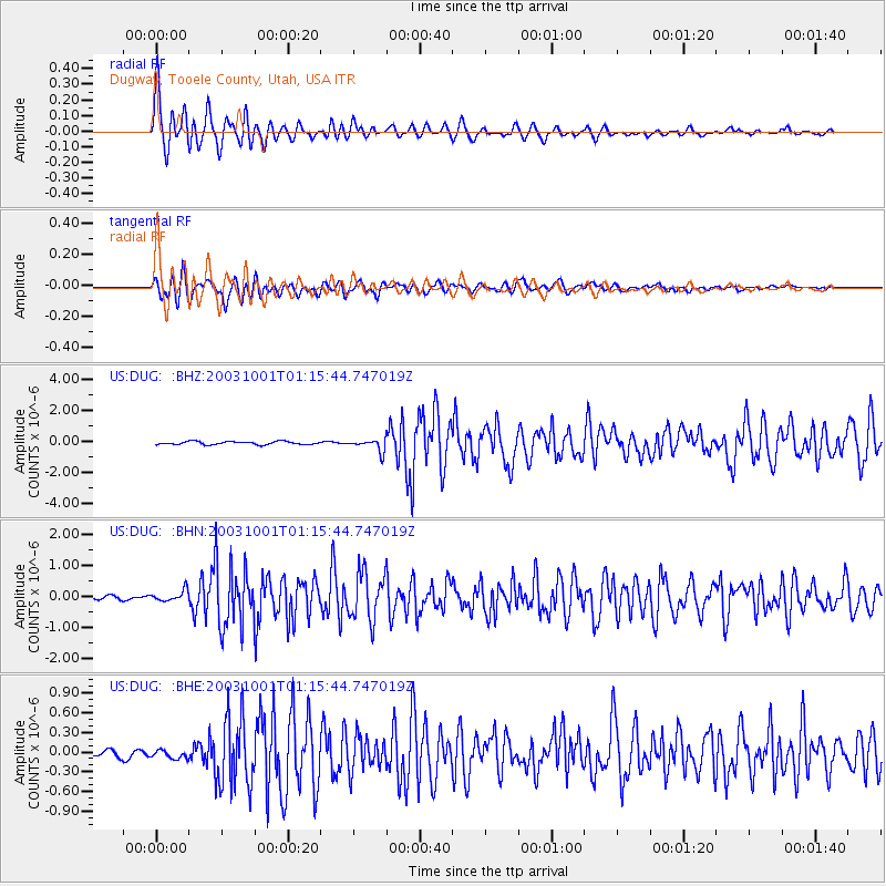
Signal To Noise
| Channel | StoN | STA | LTA |
| US:DUG: :BHN:20031001T01:15:44.747019Z | 2.615411 | 1.7626046E-7 | 6.7393024E-8 |
| US:DUG: :BHE:20031001T01:15:44.747019Z | 1.1120359 | 6.1626196E-8 | 5.5417452E-8 |
| US:DUG: :BHZ:20031001T01:15:44.747019Z | 3.8911712 | 3.9563935E-7 | 1.0167616E-7 |
| Arrivals |
| Ps | 4.5 SECOND |
| PpPs | 14 SECOND |
| PsPs/PpSs | 18 SECOND |


