You are here: Home > Network List > LD - Lamont-Doherty Cooperative Seismographic Network Stations List
> Station GEDE Greenville, DE, USA > Earthquake Result Viewer
GEDE Greenville, DE, USA - Earthquake Result Viewer
| Earthquake location: |
Off Coast Of Jalisco, Mexico |
| Earthquake latitude/longitude: |
18.0/-105.9 |
| Earthquake time(UTC): |
2016/06/02 (154) 02:23:06 GMT |
| Earthquake Depth: |
10 km |
| Earthquake Magnitude: |
5.8 MWW, 5.8 MWC |
| Earthquake Catalog/Contributor: |
NEIC PDE/NEIC COMCAT |
|
| Network: |
LD Lamont-Doherty Cooperative Seismographic Network |
| Station: |
GEDE Greenville, DE, USA |
| Lat/Lon: |
39.81 N/75.64 W |
| Elevation: |
105 m |
|
| Distance: |
34.0 deg |
| Az: |
43.953 deg |
| Baz: |
239.026 deg |
| Ray Param: |
0.07796895 |
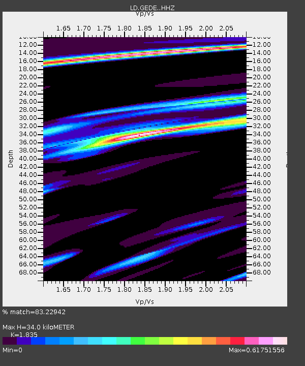
| Estimated Moho Depth: |
34.0 km |
| Estimated Crust Vp/Vs: |
1.84 |
| Assumed Crust Vp: |
6.287 km/s |
| Estimated Crust Vs: |
3.426 km/s |
| Estimated Crust Poisson's Ratio: |
0.29 |
|
| Radial Match: |
83.22942 % |
| Radial Bump: |
244 |
| Transverse Match: |
54.263927 % |
| Transverse Bump: |
325 |
| SOD ConfigId: |
7422571 |
| Insert Time: |
2019-04-22 17:43:39.798 +0000 |
| GWidth: |
2.5 |
| Max Bumps: |
400 |
| Tol: |
0.001 |
|
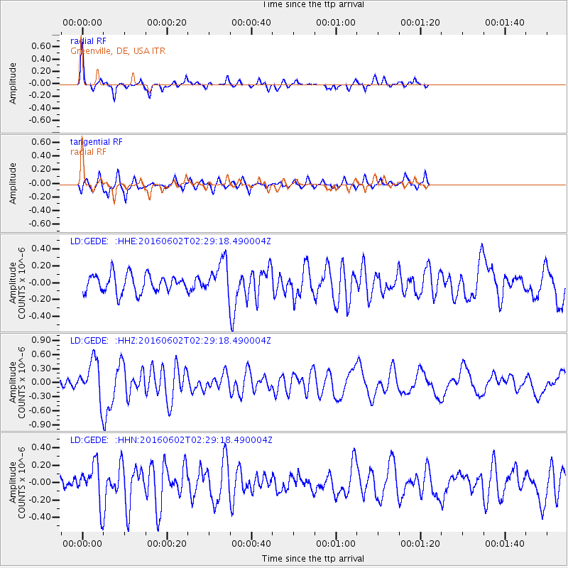
Signal To Noise
| Channel | StoN | STA | LTA |
| LD:GEDE: :HHZ:20160602T02:29:18.490004Z | 4.4142704 | 4.4991805E-7 | 1.0192354E-7 |
| LD:GEDE: :HHN:20160602T02:29:18.490004Z | 2.6880887 | 2.4286635E-7 | 9.034909E-8 |
| LD:GEDE: :HHE:20160602T02:29:18.490004Z | 2.175477 | 2.3415595E-7 | 1.076343E-7 |
| Arrivals |
| Ps | 4.8 SECOND |
| PpPs | 14 SECOND |
| PsPs/PpSs | 19 SECOND |


