You are here: Home > Network List > CI - Caltech Regional Seismic Network Stations List
> Station SHO Shoshone, CA, USA > Earthquake Result Viewer
SHO Shoshone, CA, USA - Earthquake Result Viewer
| Earthquake location: |
Tonga Islands |
| Earthquake latitude/longitude: |
-20.2/-174.1 |
| Earthquake time(UTC): |
2006/05/03 (123) 15:26:40 GMT |
| Earthquake Depth: |
55 km |
| Earthquake Magnitude: |
7.2 MB, 7.8 MS, 7.9 MW, 7.9 MW |
| Earthquake Catalog/Contributor: |
WHDF/NEIC |
|
| Network: |
CI Caltech Regional Seismic Network |
| Station: |
SHO Shoshone, CA, USA |
| Lat/Lon: |
35.90 N/116.28 W |
| Elevation: |
451 m |
|
| Distance: |
78.1 deg |
| Az: |
44.62 deg |
| Baz: |
234.353 deg |
| Ray Param: |
0.049742784 |
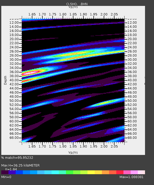
| Estimated Moho Depth: |
36.25 km |
| Estimated Crust Vp/Vs: |
1.64 |
| Assumed Crust Vp: |
6.276 km/s |
| Estimated Crust Vs: |
3.827 km/s |
| Estimated Crust Poisson's Ratio: |
0.20 |
|
| Radial Match: |
95.95232 % |
| Radial Bump: |
400 |
| Transverse Match: |
82.187706 % |
| Transverse Bump: |
400 |
| SOD ConfigId: |
2669 |
| Insert Time: |
2010-02-26 00:26:04.724 +0000 |
| GWidth: |
2.5 |
| Max Bumps: |
400 |
| Tol: |
0.001 |
|

Signal To Noise
| Channel | StoN | STA | LTA |
| CI:SHO: :BHN:20060503T15:38:02.553Z | 3.1137433 | 9.088184E-7 | 2.9187325E-7 |
| CI:SHO: :BHE:20060503T15:38:02.553Z | 3.9904122 | 1.0269623E-6 | 2.5735744E-7 |
| CI:SHO: :BHZ:20060503T15:38:02.553Z | 5.476725 | 2.9769458E-6 | 5.4356315E-7 |
| Arrivals |
| Ps | 3.8 SECOND |
| PpPs | 15 SECOND |
| PsPs/PpSs | 19 SECOND |


