You are here: Home > Network List > PE - Penn State Network Stations List
> Station PAMP Mt. Pisgah State Park, Troy, PA > Earthquake Result Viewer
PAMP Mt. Pisgah State Park, Troy, PA - Earthquake Result Viewer
| Earthquake location: |
Off Coast Of Jalisco, Mexico |
| Earthquake latitude/longitude: |
18.0/-105.9 |
| Earthquake time(UTC): |
2016/06/02 (154) 02:23:06 GMT |
| Earthquake Depth: |
10 km |
| Earthquake Magnitude: |
5.8 MWW, 5.8 MWC |
| Earthquake Catalog/Contributor: |
NEIC PDE/NEIC COMCAT |
|
| Network: |
PE Penn State Network |
| Station: |
PAMP Mt. Pisgah State Park, Troy, PA |
| Lat/Lon: |
41.81 N/76.67 W |
| Elevation: |
348 m |
|
| Distance: |
34.4 deg |
| Az: |
40.214 deg |
| Baz: |
235.26 deg |
| Ray Param: |
0.07777235 |
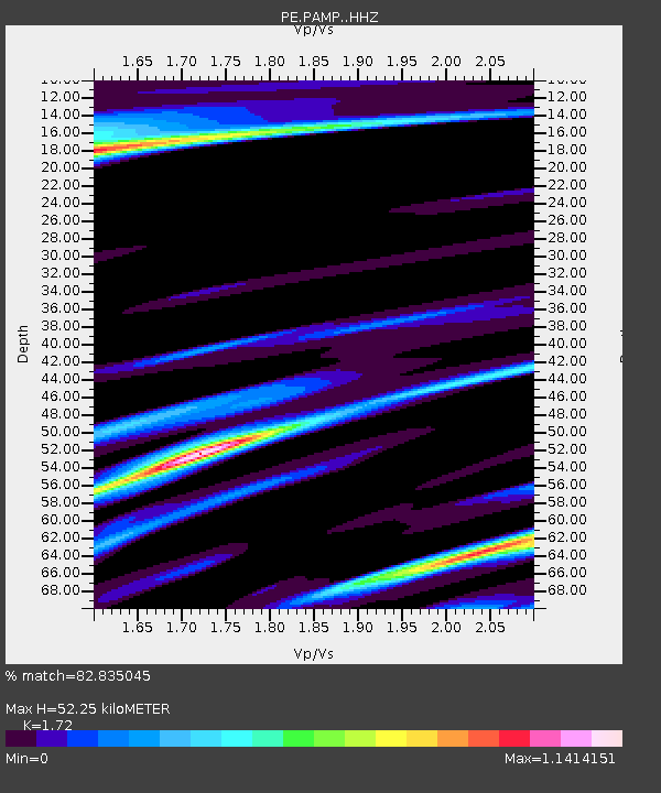
| Estimated Moho Depth: |
52.25 km |
| Estimated Crust Vp/Vs: |
1.72 |
| Assumed Crust Vp: |
6.121 km/s |
| Estimated Crust Vs: |
3.558 km/s |
| Estimated Crust Poisson's Ratio: |
0.24 |
|
| Radial Match: |
82.835045 % |
| Radial Bump: |
400 |
| Transverse Match: |
55.926807 % |
| Transverse Bump: |
400 |
| SOD ConfigId: |
7422571 |
| Insert Time: |
2019-04-22 17:45:09.635 +0000 |
| GWidth: |
2.5 |
| Max Bumps: |
400 |
| Tol: |
0.001 |
|

Signal To Noise
| Channel | StoN | STA | LTA |
| PE:PAMP: :HHZ:20160602T02:29:22.155012Z | 3.0650172 | 5.351489E-7 | 1.7459898E-7 |
| PE:PAMP: :HHN:20160602T02:29:22.155012Z | 1.2280616 | 2.725794E-7 | 2.2195906E-7 |
| PE:PAMP: :HHE:20160602T02:29:22.155012Z | 1.8050872 | 2.5719118E-7 | 1.424813E-7 |
| Arrivals |
| Ps | 6.6 SECOND |
| PpPs | 22 SECOND |
| PsPs/PpSs | 28 SECOND |


