You are here: Home > Network List > TA - USArray Transportable Network (new EarthScope stations) Stations List
> Station J26L Joseph Creek, AK, USA > Earthquake Result Viewer
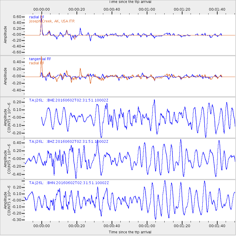
J26L Joseph Creek, AK, USA - Earthquake Result Viewer
*The percent match for this event was below the threshold and hence no stack was calculated.
| Earthquake location: |
Off Coast Of Jalisco, Mexico |
| Earthquake latitude/longitude: |
18.0/-105.9 |
| Earthquake time(UTC): |
2016/06/02 (154) 02:23:06 GMT |
| Earthquake Depth: |
10 km |
| Earthquake Magnitude: |
5.8 MWW, 5.8 MWC |
| Earthquake Catalog/Contributor: |
NEIC PDE/NEIC COMCAT |
|
| Network: |
TA USArray Transportable Network (new EarthScope stations) |
| Station: |
J26L Joseph Creek, AK, USA |
| Lat/Lon: |
64.50 N/143.56 W |
| Elevation: |
1144 m |
|
| Distance: |
52.9 deg |
| Az: |
340.615 deg |
| Baz: |
133.145 deg |
| Ray Param: |
$rayparam |
*The percent match for this event was below the threshold and hence was not used in the summary stack. |
|
| Radial Match: |
73.64829 % |
| Radial Bump: |
352 |
| Transverse Match: |
38.258793 % |
| Transverse Bump: |
400 |
| SOD ConfigId: |
7422571 |
| Insert Time: |
2019-04-22 17:46:12.728 +0000 |
| GWidth: |
2.5 |
| Max Bumps: |
400 |
| Tol: |
0.001 |
|
Signal To Noise
| Channel | StoN | STA | LTA |
| TA:J26L: :BHZ:20160602T02:31:51.10002Z | 1.4377676 | 1.090198E-7 | 7.5825746E-8 |
| TA:J26L: :BHN:20160602T02:31:51.10002Z | 1.0537676 | 8.9948394E-8 | 8.5358856E-8 |
| TA:J26L: :BHE:20160602T02:31:51.10002Z | 1.8882192 | 1.4068677E-7 | 7.4507646E-8 |
| Arrivals |
| Ps | |
| PpPs | |
| PsPs/PpSs | |


