You are here: Home > Network List > N4 - Central and EAstern US Network Stations List
> Station T45B Paducah, KY, USA > Earthquake Result Viewer
T45B Paducah, KY, USA - Earthquake Result Viewer
| Earthquake location: |
Near Coast Of Central Chile |
| Earthquake latitude/longitude: |
-29.4/-71.9 |
| Earthquake time(UTC): |
2016/06/05 (157) 05:51:09 GMT |
| Earthquake Depth: |
15 km |
| Earthquake Magnitude: |
5.7 MWP |
| Earthquake Catalog/Contributor: |
NEIC PDE/NEIC COMCAT |
|
| Network: |
N4 Central and EAstern US Network |
| Station: |
T45B Paducah, KY, USA |
| Lat/Lon: |
37.02 N/88.65 W |
| Elevation: |
136 m |
|
| Distance: |
67.9 deg |
| Az: |
345.591 deg |
| Baz: |
164.252 deg |
| Ray Param: |
0.056668825 |
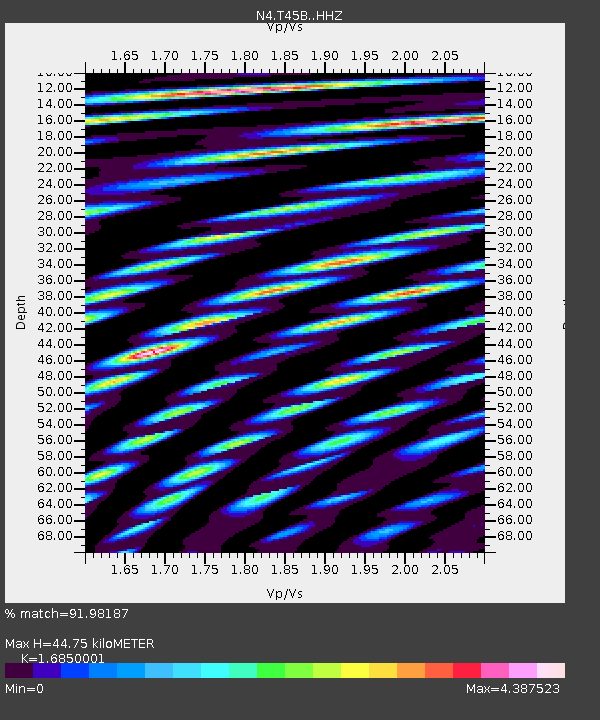
| Estimated Moho Depth: |
44.75 km |
| Estimated Crust Vp/Vs: |
1.69 |
| Assumed Crust Vp: |
6.444 km/s |
| Estimated Crust Vs: |
3.824 km/s |
| Estimated Crust Poisson's Ratio: |
0.23 |
|
| Radial Match: |
91.98187 % |
| Radial Bump: |
400 |
| Transverse Match: |
85.34449 % |
| Transverse Bump: |
400 |
| SOD ConfigId: |
7422571 |
| Insert Time: |
2019-04-22 17:52:46.911 +0000 |
| GWidth: |
2.5 |
| Max Bumps: |
400 |
| Tol: |
0.001 |
|

Signal To Noise
| Channel | StoN | STA | LTA |
| N4:T45B: :HHZ:20160605T06:01:36.250Z | 4.045103 | 4.1890033E-7 | 1.0355739E-7 |
| N4:T45B: :HHN:20160605T06:01:36.250Z | 5.085744 | 5.6427314E-7 | 1.1095194E-7 |
| N4:T45B: :HHE:20160605T06:01:36.250Z | 2.9580593 | 2.421429E-7 | 8.185871E-8 |
| Arrivals |
| Ps | 5.0 SECOND |
| PpPs | 18 SECOND |
| PsPs/PpSs | 23 SECOND |


