You are here: Home > Network List > TA - USArray Transportable Network (new EarthScope stations) Stations List
> Station M53A WI Miller and Sons, Farmdale, OH, USA > Earthquake Result Viewer
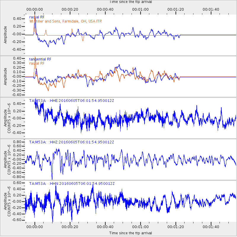
M53A WI Miller and Sons, Farmdale, OH, USA - Earthquake Result Viewer
*The percent match for this event was below the threshold and hence no stack was calculated.
| Earthquake location: |
Near Coast Of Central Chile |
| Earthquake latitude/longitude: |
-29.4/-71.9 |
| Earthquake time(UTC): |
2016/06/05 (157) 05:51:09 GMT |
| Earthquake Depth: |
15 km |
| Earthquake Magnitude: |
5.7 MWP |
| Earthquake Catalog/Contributor: |
NEIC PDE/NEIC COMCAT |
|
| Network: |
TA USArray Transportable Network (new EarthScope stations) |
| Station: |
M53A WI Miller and Sons, Farmdale, OH, USA |
| Lat/Lon: |
41.44 N/80.68 W |
| Elevation: |
334 m |
|
| Distance: |
70.9 deg |
| Az: |
353.036 deg |
| Baz: |
171.906 deg |
| Ray Param: |
$rayparam |
*The percent match for this event was below the threshold and hence was not used in the summary stack. |
|
| Radial Match: |
46.71402 % |
| Radial Bump: |
400 |
| Transverse Match: |
24.209793 % |
| Transverse Bump: |
400 |
| SOD ConfigId: |
7422571 |
| Insert Time: |
2019-04-22 17:55:59.052 +0000 |
| GWidth: |
2.5 |
| Max Bumps: |
400 |
| Tol: |
0.001 |
|
Signal To Noise
| Channel | StoN | STA | LTA |
| TA:M53A: :HHZ:20160605T06:01:54.950012Z | 1.7559787 | 2.3218129E-7 | 1.3222329E-7 |
| TA:M53A: :HHN:20160605T06:01:54.950012Z | 1.2566603 | 2.3437526E-7 | 1.8650645E-7 |
| TA:M53A: :HHE:20160605T06:01:54.950012Z | 1.2305819 | 2.0648272E-7 | 1.6779275E-7 |
| Arrivals |
| Ps | |
| PpPs | |
| PsPs/PpSs | |


