You are here: Home > Network List > TA - USArray Transportable Network (new EarthScope stations) Stations List
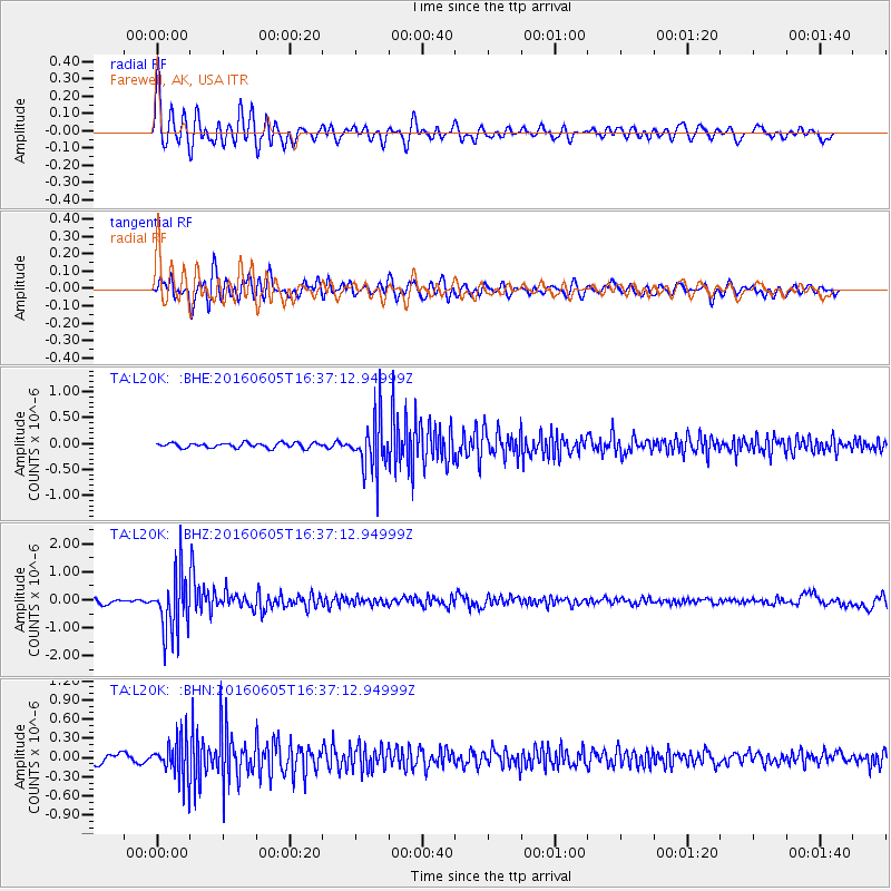
> Station L20K Farewell, AK, USA > Earthquake Result Viewer
L20K Farewell, AK, USA - Earthquake Result Viewer
| Earthquake location: |
Banda Sea |
| Earthquake latitude/longitude: |
-4.6/125.6 |
| Earthquake time(UTC): |
2016/06/05 (157) 16:25:33 GMT |
| Earthquake Depth: |
429 km |
| Earthquake Magnitude: |
6.3 MWB |
| Earthquake Catalog/Contributor: |
NEIC PDE/NEIC COMCAT |
|
| Network: |
TA USArray Transportable Network (new EarthScope stations) |
| Station: |
L20K Farewell, AK, USA |
| Lat/Lon: |
62.48 N/153.88 W |
| Elevation: |
673 m |
|
| Distance: |
89.6 deg |
| Az: |
27.268 deg |
| Baz: |
259.478 deg |
| Ray Param: |
0.04162202 |
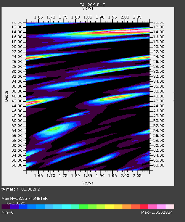
| Estimated Moho Depth: |
13.25 km |
| Estimated Crust Vp/Vs: |
2.02 |
| Assumed Crust Vp: |
6.566 km/s |
| Estimated Crust Vs: |
3.247 km/s |
| Estimated Crust Poisson's Ratio: |
0.34 |
|
| Radial Match: |
81.30292 % |
| Radial Bump: |
400 |
| Transverse Match: |
65.79996 % |
| Transverse Bump: |
400 |
| SOD ConfigId: |
7422571 |
| Insert Time: |
2019-04-22 18:02:57.835 +0000 |
| GWidth: |
2.5 |
| Max Bumps: |
400 |
| Tol: |
0.001 |
|
Signal To Noise
| Channel | StoN | STA | LTA |
| TA:L20K: :BHZ:20160605T16:37:12.94999Z | 12.751258 | 1.0624525E-6 | 8.332139E-8 |
| TA:L20K: :BHN:20160605T16:37:12.94999Z | 3.917195 | 3.1986355E-7 | 8.1656275E-8 |
| TA:L20K: :BHE:20160605T16:37:12.94999Z | 10.641498 | 5.015677E-7 | 4.7133184E-8 |
| Arrivals |
| Ps | 2.1 SECOND |
| PpPs | 6.0 SECOND |
| PsPs/PpSs | 8.1 SECOND |


