You are here: Home > Network List > XL12 - Hangay Dome, Mongolia Stations List
> Station AT01 AT01 > Earthquake Result Viewer
AT01 AT01 - Earthquake Result Viewer
| Earthquake location: |
Banda Sea |
| Earthquake latitude/longitude: |
-4.6/125.6 |
| Earthquake time(UTC): |
2016/06/05 (157) 16:25:33 GMT |
| Earthquake Depth: |
429 km |
| Earthquake Magnitude: |
6.3 MWB |
| Earthquake Catalog/Contributor: |
NEIC PDE/NEIC COMCAT |
|
| Network: |
XL Hangay Dome, Mongolia |
| Station: |
AT01 AT01 |
| Lat/Lon: |
45.36 N/93.62 E |
| Elevation: |
1561 m |
|
| Distance: |
57.3 deg |
| Az: |
333.653 deg |
| Baz: |
141.131 deg |
| Ray Param: |
0.06192857 |
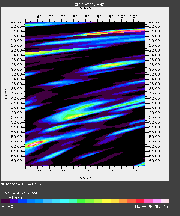
| Estimated Moho Depth: |
60.75 km |
| Estimated Crust Vp/Vs: |
1.63 |
| Assumed Crust Vp: |
6.353 km/s |
| Estimated Crust Vs: |
3.886 km/s |
| Estimated Crust Poisson's Ratio: |
0.20 |
|
| Radial Match: |
83.641716 % |
| Radial Bump: |
400 |
| Transverse Match: |
64.93186 % |
| Transverse Bump: |
400 |
| SOD ConfigId: |
7422571 |
| Insert Time: |
2019-04-22 18:03:37.049 +0000 |
| GWidth: |
2.5 |
| Max Bumps: |
400 |
| Tol: |
0.001 |
|

Signal To Noise
| Channel | StoN | STA | LTA |
| XL:AT01: :HHZ:20160605T16:34:08.329995Z | 69.73946 | 1.7838317E-6 | 2.5578512E-8 |
| XL:AT01: :HHN:20160605T16:34:08.329995Z | 67.7108 | 7.867751E-7 | 1.16196395E-8 |
| XL:AT01: :HHE:20160605T16:34:08.329995Z | 42.73351 | 6.5724544E-7 | 1.5380094E-8 |
| Arrivals |
| Ps | 6.4 SECOND |
| PpPs | 24 SECOND |
| PsPs/PpSs | 30 SECOND |


