You are here: Home > Network List > XL12 - Hangay Dome, Mongolia Stations List
> Station AT09 AT09 > Earthquake Result Viewer
AT09 AT09 - Earthquake Result Viewer
| Earthquake location: |
Banda Sea |
| Earthquake latitude/longitude: |
-4.6/125.6 |
| Earthquake time(UTC): |
2016/06/05 (157) 16:25:33 GMT |
| Earthquake Depth: |
429 km |
| Earthquake Magnitude: |
6.3 MWB |
| Earthquake Catalog/Contributor: |
NEIC PDE/NEIC COMCAT |
|
| Network: |
XL Hangay Dome, Mongolia |
| Station: |
AT09 AT09 |
| Lat/Lon: |
44.93 N/95.56 E |
| Elevation: |
1861 m |
|
| Distance: |
56.2 deg |
| Az: |
334.633 deg |
| Baz: |
143.04 deg |
| Ray Param: |
0.06267702 |
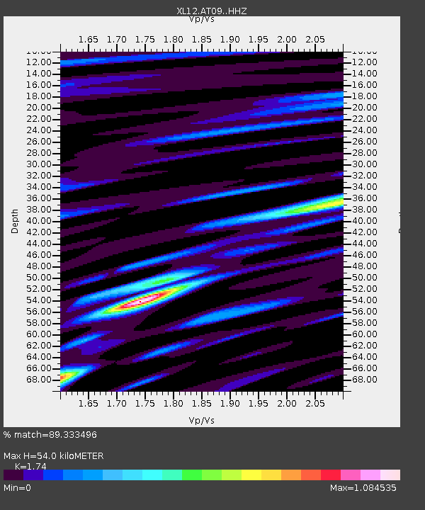
| Estimated Moho Depth: |
54.0 km |
| Estimated Crust Vp/Vs: |
1.74 |
| Assumed Crust Vp: |
6.353 km/s |
| Estimated Crust Vs: |
3.651 km/s |
| Estimated Crust Poisson's Ratio: |
0.25 |
|
| Radial Match: |
89.333496 % |
| Radial Bump: |
400 |
| Transverse Match: |
78.67909 % |
| Transverse Bump: |
400 |
| SOD ConfigId: |
7422571 |
| Insert Time: |
2019-04-22 18:03:43.489 +0000 |
| GWidth: |
2.5 |
| Max Bumps: |
400 |
| Tol: |
0.001 |
|

Signal To Noise
| Channel | StoN | STA | LTA |
| XL:AT09: :HHZ:20160605T16:34:00.160012Z | 105.78072 | 2.8594648E-6 | 2.7032003E-8 |
| XL:AT09: :HHN:20160605T16:34:00.160012Z | 52.104713 | 1.1104418E-6 | 2.1311733E-8 |
| XL:AT09: :HHE:20160605T16:34:00.160012Z | 53.66079 | 9.857379E-7 | 1.8369798E-8 |
| Arrivals |
| Ps | 6.6 SECOND |
| PpPs | 22 SECOND |
| PsPs/PpSs | 29 SECOND |


