You are here: Home > Network List > US - United States National Seismic Network Stations List
> Station DUG Dugway, Tooele County, Utah, USA > Earthquake Result Viewer
DUG Dugway, Tooele County, Utah, USA - Earthquake Result Viewer

| Earthquake location: |
Off East Coast Of Honshu, Japan |
| Earthquake latitude/longitude: |
38.1/144.9 |
| Earthquake time(UTC): |
2005/11/14 (318) 21:38:51 GMT |
| Earthquake Depth: |
11 km |
| Earthquake Magnitude: |
6.7 MB, 6.8 MS, 7.0 MW, 6.9 MW |
| Earthquake Catalog/Contributor: |
WHDF/NEIC |
|
| Network: |
US United States National Seismic Network |
| Station: |
DUG Dugway, Tooele County, Utah, USA |
| Lat/Lon: |
40.19 N/112.81 W |
| Elevation: |
1477 m |
|
| Distance: |
74.5 deg |
| Az: |
50.941 deg |
| Baz: |
306.899 deg |
| Ray Param: |
0.05225834 |
| Estimated Moho Depth: |
65.0 km |
| Estimated Crust Vp/Vs: |
2.10 |
| Assumed Crust Vp: |
6.276 km/s |
| Estimated Crust Vs: |
2.996 km/s |
| Estimated Crust Poisson's Ratio: |
0.35 |
|
| Radial Match: |
96.545044 % |
| Radial Bump: |
400 |
| Transverse Match: |
92.725494 % |
| Transverse Bump: |
400 |
| SOD ConfigId: |
2448 |
| Insert Time: |
2010-03-05 04:13:17.794 +0000 |
| GWidth: |
2.5 |
| Max Bumps: |
400 |
| Tol: |
0.001 |
|
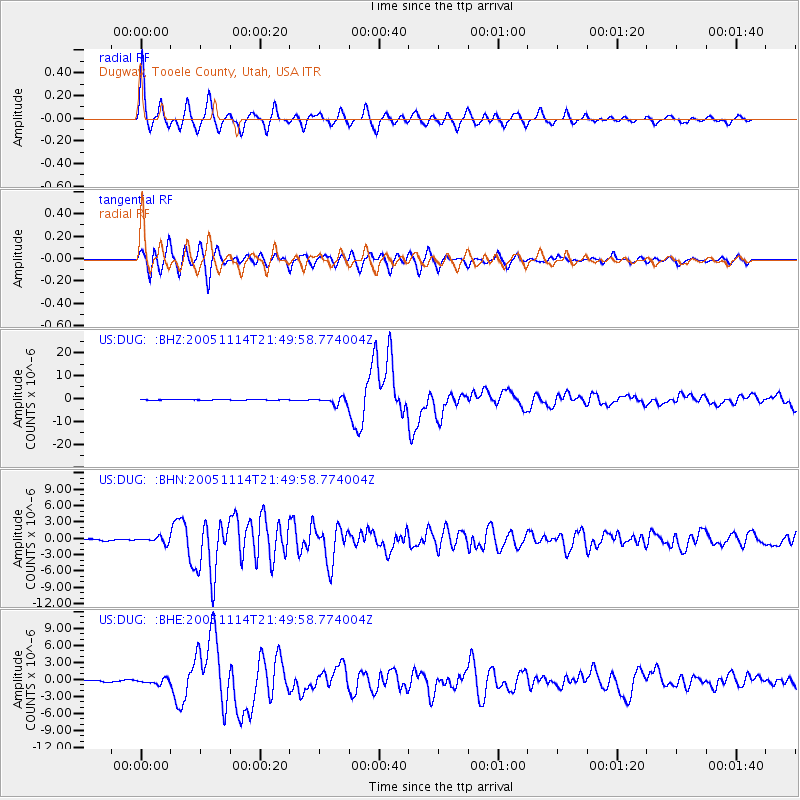
Signal To Noise
| Channel | StoN | STA | LTA |
| US:DUG: :BHN:20051114T21:49:58.774004Z | 3.9154556 | 5.4037724E-7 | 1.3801134E-7 |
| US:DUG: :BHE:20051114T21:49:58.774004Z | 5.145481 | 4.4004466E-7 | 8.5520604E-8 |
| US:DUG: :BHZ:20051114T21:49:58.774004Z | 13.86062 | 1.51251E-6 | 1.0912283E-7 |
| Arrivals |
| Ps | 12 SECOND |
| PpPs | 31 SECOND |
| PsPs/PpSs | 43 SECOND |


