You are here: Home > Network List > US - United States National Seismic Network Stations List
> Station DUG Dugway, Tooele County, Utah, USA > Earthquake Result Viewer
DUG Dugway, Tooele County, Utah, USA - Earthquake Result Viewer
| Earthquake location: |
Kodiak Island Region, Alaska |
| Earthquake latitude/longitude: |
56.4/-152.9 |
| Earthquake time(UTC): |
1999/05/07 (127) 14:13:52 GMT |
| Earthquake Depth: |
20 km |
| Earthquake Magnitude: |
5.7 MB, 6.1 MS, 6.4 MW, 5.7 ME |
| Earthquake Catalog/Contributor: |
WHDF/NEIC |
|
| Network: |
US United States National Seismic Network |
| Station: |
DUG Dugway, Tooele County, Utah, USA |
| Lat/Lon: |
40.19 N/112.81 W |
| Elevation: |
1477 m |
|
| Distance: |
30.7 deg |
| Az: |
104.717 deg |
| Baz: |
315.435 deg |
| Ray Param: |
0.07925353 |
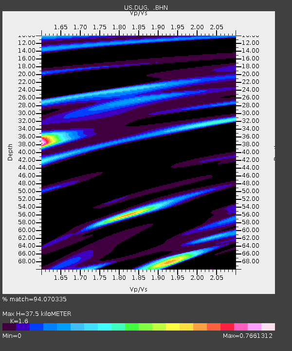
| Estimated Moho Depth: |
37.5 km |
| Estimated Crust Vp/Vs: |
1.60 |
| Assumed Crust Vp: |
6.276 km/s |
| Estimated Crust Vs: |
3.922 km/s |
| Estimated Crust Poisson's Ratio: |
0.18 |
|
| Radial Match: |
94.070335 % |
| Radial Bump: |
400 |
| Transverse Match: |
79.98624 % |
| Transverse Bump: |
400 |
| SOD ConfigId: |
110177 |
| Insert Time: |
2010-03-05 04:13:31.652 +0000 |
| GWidth: |
2.5 |
| Max Bumps: |
400 |
| Tol: |
0.001 |
|

Signal To Noise
| Channel | StoN | STA | LTA |
| US:DUG: :BHN:19990507T14:19:35.115005Z | 4.1581607 | 1.8413279E-7 | 4.428227E-8 |
| US:DUG: :BHE:19990507T14:19:35.115005Z | 2.9586337 | 1.9753445E-7 | 6.676543E-8 |
| US:DUG: :BHZ:19990507T14:19:35.115005Z | 5.421735 | 4.3026844E-7 | 7.935992E-8 |
| Arrivals |
| Ps | 3.9 SECOND |
| PpPs | 14 SECOND |
| PsPs/PpSs | 18 SECOND |


