You are here: Home > Network List > CI - Caltech Regional Seismic Network Stations List
> Station SWS Sam W. Stewart, Westmorland, CA, USA > Earthquake Result Viewer
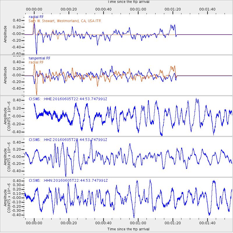
SWS Sam W. Stewart, Westmorland, CA, USA - Earthquake Result Viewer
*The percent match for this event was below the threshold and hence no stack was calculated.
| Earthquake location: |
Tonga Islands Region |
| Earthquake latitude/longitude: |
-17.6/-172.6 |
| Earthquake time(UTC): |
2016/06/05 (157) 22:33:49 GMT |
| Earthquake Depth: |
10 km |
| Earthquake Magnitude: |
5.6 MWW, 5.6 MWC, 5.6 MWB |
| Earthquake Catalog/Contributor: |
NEIC PDE/NEIC COMCAT |
|
| Network: |
CI Caltech Regional Seismic Network |
| Station: |
SWS Sam W. Stewart, Westmorland, CA, USA |
| Lat/Lon: |
32.94 N/115.80 W |
| Elevation: |
140 m |
|
| Distance: |
74.0 deg |
| Az: |
47.077 deg |
| Baz: |
236.135 deg |
| Ray Param: |
$rayparam |
*The percent match for this event was below the threshold and hence was not used in the summary stack. |
|
| Radial Match: |
56.670578 % |
| Radial Bump: |
400 |
| Transverse Match: |
54.608303 % |
| Transverse Bump: |
400 |
| SOD ConfigId: |
7422571 |
| Insert Time: |
2019-04-22 18:07:22.253 +0000 |
| GWidth: |
2.5 |
| Max Bumps: |
400 |
| Tol: |
0.001 |
|
Signal To Noise
| Channel | StoN | STA | LTA |
| CI:SWS: :HHZ:20160605T22:44:53.747991Z | 1.985801 | 1.208711E-7 | 6.0867684E-8 |
| CI:SWS: :HHN:20160605T22:44:53.747991Z | 1.495265 | 1.768712E-7 | 1.1828752E-7 |
| CI:SWS: :HHE:20160605T22:44:53.747991Z | 2.059145 | 2.2993474E-7 | 1.1166516E-7 |
| Arrivals |
| Ps | |
| PpPs | |
| PsPs/PpSs | |


