You are here: Home > Network List > US - United States National Seismic Network Stations List
> Station DUG Dugway, Tooele County, Utah, USA > Earthquake Result Viewer
DUG Dugway, Tooele County, Utah, USA - Earthquake Result Viewer

| Earthquake location: |
Costa Rica |
| Earthquake latitude/longitude: |
9.0/-84.2 |
| Earthquake time(UTC): |
1999/08/20 (232) 10:02:21 GMT |
| Earthquake Depth: |
20 km |
| Earthquake Magnitude: |
6.1 MB, 6.9 MS, 7.0 MW, 6.1 ML |
| Earthquake Catalog/Contributor: |
WHDF/NEIC |
|
| Network: |
US United States National Seismic Network |
| Station: |
DUG Dugway, Tooele County, Utah, USA |
| Lat/Lon: |
40.19 N/112.81 W |
| Elevation: |
1477 m |
|
| Distance: |
40.2 deg |
| Az: |
325.277 deg |
| Baz: |
132.734 deg |
| Ray Param: |
0.07453177 |
| Estimated Moho Depth: |
32.0 km |
| Estimated Crust Vp/Vs: |
1.60 |
| Assumed Crust Vp: |
6.276 km/s |
| Estimated Crust Vs: |
3.922 km/s |
| Estimated Crust Poisson's Ratio: |
0.18 |
|
| Radial Match: |
94.42879 % |
| Radial Bump: |
232 |
| Transverse Match: |
70.89131 % |
| Transverse Bump: |
400 |
| SOD ConfigId: |
110177 |
| Insert Time: |
2010-03-05 04:13:47.752 +0000 |
| GWidth: |
2.5 |
| Max Bumps: |
400 |
| Tol: |
0.001 |
|
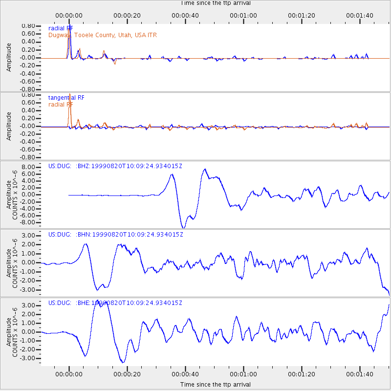
Signal To Noise
| Channel | StoN | STA | LTA |
| US:DUG: :BHN:19990820T10:09:24.934015Z | 12.986825 | 6.551561E-7 | 5.044775E-8 |
| US:DUG: :BHE:19990820T10:09:24.934015Z | 14.594646 | 9.006241E-7 | 6.170921E-8 |
| US:DUG: :BHZ:19990820T10:09:24.934015Z | 34.391594 | 2.1680312E-6 | 6.303957E-8 |
| Arrivals |
| Ps | 3.3 SECOND |
| PpPs | 12 SECOND |
| PsPs/PpSs | 16 SECOND |


