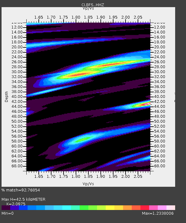
BFS Mt Baldy Forest Station - Earthquake Result Viewer

Earthquake location: Kermadec Islands, New Zealand
Earthquake latitude/longitude: -30.0/-177.8
Earthquake time(UTC): 2016/06/06 (158) 02:35:32 GMT
Earthquake Depth: 44 km
Earthquake Magnitude: 6.1 MWW, 6.0 MWC, 6.1 MWC
Earthquake Catalog/Contributor: NEIC PDE/NEIC COMCAT
Network: CI Caltech Regional Seismic Network
Station: BFS Mt Baldy Forest Station
Lat/Lon: 34.24 N/117.66 W
Elevation: 1312 m
Distance: 85.5 deg
Az: 46.134 deg
Baz: 229.003 deg
Ray Param: 0.044652324
Estimated Moho Depth: 42.5 km
Estimated Crust Vp/Vs: 2.10
Assumed Crust Vp: 6.276 km/s
Estimated Crust Vs: 2.992 km/s
Estimated Crust Poisson's Ratio: 0.35
Radial Match: 92.76854 %
Radial Bump: 400
Transverse Match: 85.37074 %
Transverse Bump: 400
SOD ConfigId: 7422571
Insert Time: 2019-04-22 18:15:40.985 +0000
GWidth: 2.5
Max Bumps: 400
Tol: 0.001

Signal To Noise

ChannelStoNSTALTA
CI:BFS: :HHZ:20160606T02:47:34.478013Z8.4902336.384559E-77.519886E-8
CI:BFS: :HHN:20160606T02:47:34.478013Z2.8845061.6187882E-75.612012E-8
CI:BFS: :HHE:20160606T02:47:34.478013Z2.94877531.5863706E-75.379761E-8
Arrivals
Ps7.6 SECOND
PpPs21 SECOND
PsPs/PpSs28 SECOND