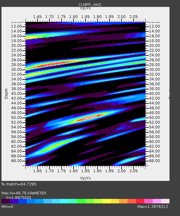
MPP McPhearson Peak - Earthquake Result Viewer
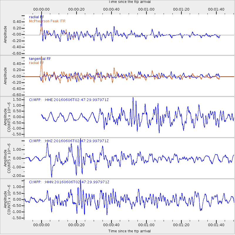
Earthquake location: Kermadec Islands, New Zealand
Earthquake latitude/longitude: -30.0/-177.8
Earthquake time(UTC): 2016/06/06 (158) 02:35:32 GMT
Earthquake Depth: 44 km
Earthquake Magnitude: 6.1 MWW, 6.0 MWC, 6.1 MWC
Earthquake Catalog/Contributor: NEIC PDE/NEIC COMCAT
Network: CI Caltech Regional Seismic Network
Station: MPP McPhearson Peak
Lat/Lon: 34.89 N/119.81 W
Elevation: 1739 m
Distance: 84.6 deg
Az: 44.461 deg
Baz: 227.642 deg
Ray Param: 0.045296144
Estimated Moho Depth: 49.75 km
Estimated Crust Vp/Vs: 1.87
Assumed Crust Vp: 6.1 km/s
Estimated Crust Vs: 3.266 km/s
Estimated Crust Poisson's Ratio: 0.30
Radial Match: 84.7295 %
Radial Bump: 400
Transverse Match: 68.17118 %
Transverse Bump: 400
SOD ConfigId: 7422571
Insert Time: 2019-04-22 18:16:04.163 +0000
GWidth: 2.5
Max Bumps: 400
Tol: 0.001

Signal To Noise

ChannelStoNSTALTA
CI:MPP: :HHZ:20160606T02:47:29.997971Z4.6192136.36611E-71.3781806E-7
CI:MPP: :HHN:20160606T02:47:29.997971Z1.79503132.5638042E-71.4282782E-7
CI:MPP: :HHE:20160606T02:47:29.997971Z1.6226373.738382E-72.3038929E-7
Arrivals
Ps7.2 SECOND
PpPs23 SECOND
PsPs/PpSs30 SECOND