You are here: Home > Network List > TA - USArray Transportable Network (new EarthScope stations) Stations List
> Station I23K Minto, Yukon-Koyukuk, AK, USA > Earthquake Result Viewer
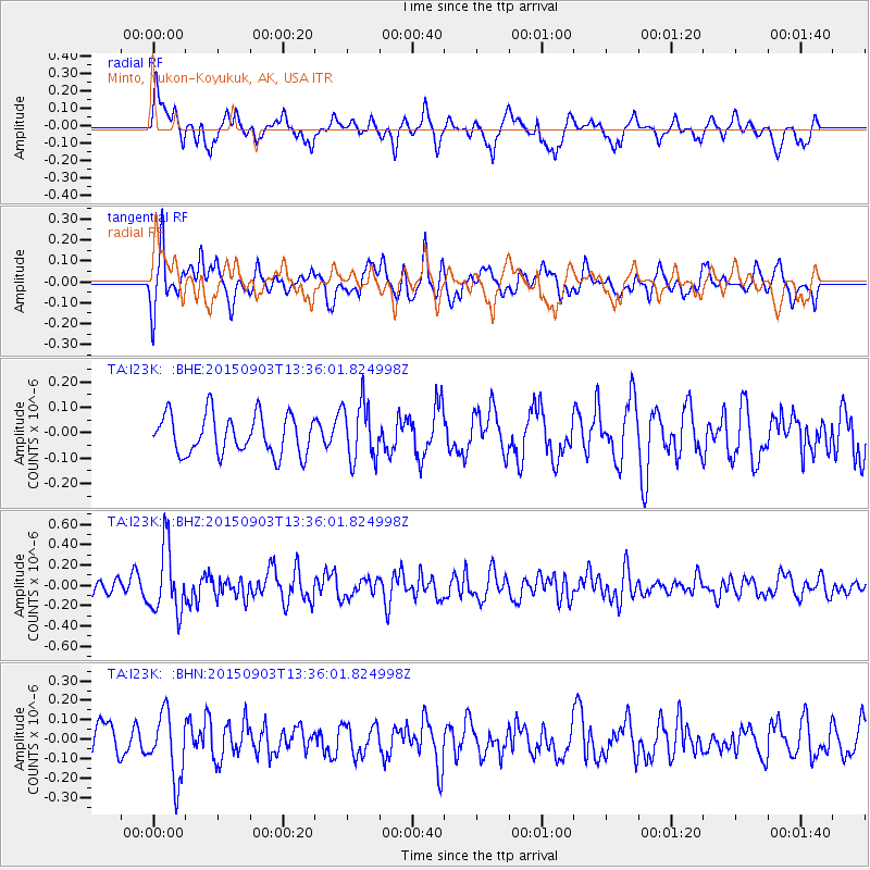
I23K Minto, Yukon-Koyukuk, AK, USA - Earthquake Result Viewer
*The percent match for this event was below the threshold and hence no stack was calculated.
| Earthquake location: |
Northern Molucca Sea |
| Earthquake latitude/longitude: |
2.1/126.7 |
| Earthquake time(UTC): |
2015/09/03 (246) 13:23:59 GMT |
| Earthquake Depth: |
44 km |
| Earthquake Magnitude: |
5.6 MB |
| Earthquake Catalog/Contributor: |
NEIC PDE/NEIC COMCAT |
|
| Network: |
TA USArray Transportable Network (new EarthScope stations) |
| Station: |
I23K Minto, Yukon-Koyukuk, AK, USA |
| Lat/Lon: |
65.15 N/149.36 W |
| Elevation: |
149 m |
|
| Distance: |
85.6 deg |
| Az: |
24.929 deg |
| Baz: |
265.367 deg |
| Ray Param: |
$rayparam |
*The percent match for this event was below the threshold and hence was not used in the summary stack. |
|
| Radial Match: |
67.20428 % |
| Radial Bump: |
400 |
| Transverse Match: |
62.602432 % |
| Transverse Bump: |
400 |
| SOD ConfigId: |
1156111 |
| Insert Time: |
2015-09-17 14:00:54.355 +0000 |
| GWidth: |
2.5 |
| Max Bumps: |
400 |
| Tol: |
0.001 |
|
Signal To Noise
| Channel | StoN | STA | LTA |
| TA:I23K: :BHZ:20150903T13:36:01.824998Z | 4.250416 | 3.2589185E-7 | 7.667293E-8 |
| TA:I23K: :BHN:20150903T13:36:01.824998Z | 2.257296 | 1.7066539E-7 | 7.5606124E-8 |
| TA:I23K: :BHE:20150903T13:36:01.824998Z | 1.4746897 | 1.1415054E-7 | 7.740648E-8 |
| Arrivals |
| Ps | |
| PpPs | |
| PsPs/PpSs | |


