You are here: Home > Network List > CI - Caltech Regional Seismic Network Stations List
> Station SWS Sam W. Stewart, Westmorland, CA, USA > Earthquake Result Viewer
SWS Sam W. Stewart, Westmorland, CA, USA - Earthquake Result Viewer
| Earthquake location: |
Kermadec Islands, New Zealand |
| Earthquake latitude/longitude: |
-30.0/-177.8 |
| Earthquake time(UTC): |
2016/06/06 (158) 02:35:32 GMT |
| Earthquake Depth: |
44 km |
| Earthquake Magnitude: |
6.1 MWW, 6.0 MWC, 6.1 MWC |
| Earthquake Catalog/Contributor: |
NEIC PDE/NEIC COMCAT |
|
| Network: |
CI Caltech Regional Seismic Network |
| Station: |
SWS Sam W. Stewart, Westmorland, CA, USA |
| Lat/Lon: |
32.94 N/115.80 W |
| Elevation: |
140 m |
|
| Distance: |
85.8 deg |
| Az: |
48.133 deg |
| Baz: |
230.18 deg |
| Ray Param: |
0.044406455 |
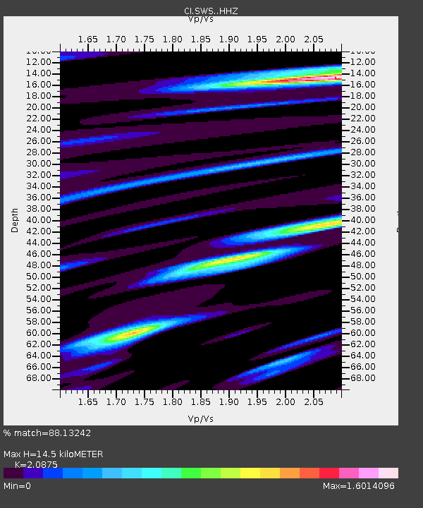
| Estimated Moho Depth: |
14.5 km |
| Estimated Crust Vp/Vs: |
2.09 |
| Assumed Crust Vp: |
6.155 km/s |
| Estimated Crust Vs: |
2.948 km/s |
| Estimated Crust Poisson's Ratio: |
0.35 |
|
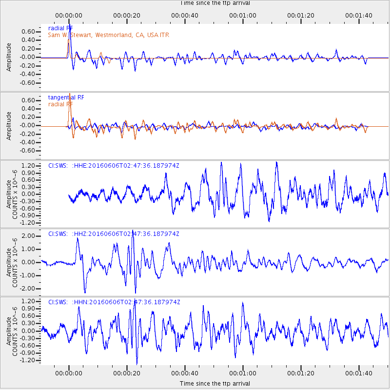
| Radial Match: |
88.13242 % |
| Radial Bump: |
400 |
| Transverse Match: |
79.92489 % |
| Transverse Bump: |
400 |
| SOD ConfigId: |
7422571 |
| Insert Time: |
2019-04-22 18:16:19.106 +0000 |
| GWidth: |
2.5 |
| Max Bumps: |
400 |
| Tol: |
0.001 |
|
Signal To Noise
| Channel | StoN | STA | LTA |
| CI:SWS: :HHZ:20160606T02:47:36.187974Z | 7.184936 | 7.088734E-7 | 9.866106E-8 |
| CI:SWS: :HHN:20160606T02:47:36.187974Z | 2.8371947 | 3.875943E-7 | 1.366118E-7 |
| CI:SWS: :HHE:20160606T02:47:36.187974Z | 2.0284078 | 3.4170094E-7 | 1.6845772E-7 |
| Arrivals |
| Ps | 2.6 SECOND |
| PpPs | 7.1 SECOND |
| PsPs/PpSs | 9.8 SECOND |


