You are here: Home > Network List > TA - USArray Transportable Network (new EarthScope stations) Stations List
> Station I23K Minto, Yukon-Koyukuk, AK, USA > Earthquake Result Viewer
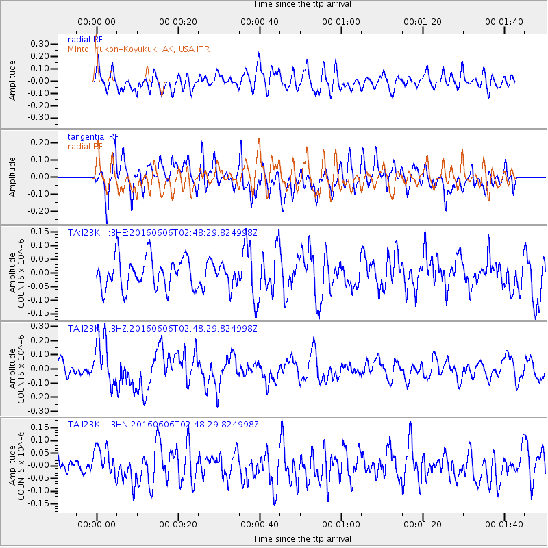
I23K Minto, Yukon-Koyukuk, AK, USA - Earthquake Result Viewer
*The percent match for this event was below the threshold and hence no stack was calculated.
| Earthquake location: |
Kermadec Islands, New Zealand |
| Earthquake latitude/longitude: |
-30.0/-177.8 |
| Earthquake time(UTC): |
2016/06/06 (158) 02:35:32 GMT |
| Earthquake Depth: |
44 km |
| Earthquake Magnitude: |
6.1 MWW, 6.0 MWC, 6.1 MWC |
| Earthquake Catalog/Contributor: |
NEIC PDE/NEIC COMCAT |
|
| Network: |
TA USArray Transportable Network (new EarthScope stations) |
| Station: |
I23K Minto, Yukon-Koyukuk, AK, USA |
| Lat/Lon: |
65.15 N/149.36 W |
| Elevation: |
149 m |
|
| Distance: |
97.4 deg |
| Az: |
11.724 deg |
| Baz: |
204.644 deg |
| Ray Param: |
$rayparam |
*The percent match for this event was below the threshold and hence was not used in the summary stack. |
|
| Radial Match: |
63.155094 % |
| Radial Bump: |
400 |
| Transverse Match: |
66.97385 % |
| Transverse Bump: |
400 |
| SOD ConfigId: |
7422571 |
| Insert Time: |
2019-04-22 18:19:04.438 +0000 |
| GWidth: |
2.5 |
| Max Bumps: |
400 |
| Tol: |
0.001 |
|
Signal To Noise
| Channel | StoN | STA | LTA |
| TA:I23K: :BHZ:20160606T02:48:29.824998Z | 2.638103 | 1.698534E-7 | 6.438467E-8 |
| TA:I23K: :BHN:20160606T02:48:29.824998Z | 1.2037684 | 5.844822E-8 | 4.8554373E-8 |
| TA:I23K: :BHE:20160606T02:48:29.824998Z | 0.63295937 | 3.640043E-8 | 5.750832E-8 |
| Arrivals |
| Ps | |
| PpPs | |
| PsPs/PpSs | |


