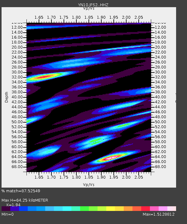
JFS2 JFS2 - Earthquake Result Viewer

Earthquake location: Kermadec Islands, New Zealand
Earthquake latitude/longitude: -30.0/-177.8
Earthquake time(UTC): 2016/06/06 (158) 02:35:32 GMT
Earthquake Depth: 44 km
Earthquake Magnitude: 6.1 MWW, 6.0 MWC, 6.1 MWC
Earthquake Catalog/Contributor: NEIC PDE/NEIC COMCAT
Network: YN San Jacinto Fault Zone
Station: JFS2 JFS2
Lat/Lon: 33.42 N/116.40 W
Elevation: 645 m
Distance: 85.8 deg
Az: 47.436 deg
Baz: 229.798 deg
Ray Param: 0.044463478
Estimated Moho Depth: 64.25 km
Estimated Crust Vp/Vs: 1.94
Assumed Crust Vp: 6.264 km/s
Estimated Crust Vs: 3.229 km/s
Estimated Crust Poisson's Ratio: 0.32
Radial Match: 87.52549 %
Radial Bump: 400
Transverse Match: 65.35072 %
Transverse Bump: 400
SOD ConfigId: 7422571
Insert Time: 2019-04-22 18:21:36.606 +0000
GWidth: 2.5
Max Bumps: 400
Tol: 0.001

Signal To Noise

ChannelStoNSTALTA
YN:JFS2: :HHZ:20160606T02:47:35.783982Z9.6594496.403708E-76.629476E-8
YN:JFS2: :HHN:20160606T02:47:35.783982Z1.23648011.07658636E-78.7068635E-8
YN:JFS2: :HHE:20160606T02:47:35.783982Z2.03410271.9815668E-79.741724E-8
Arrivals
Ps9.8 SECOND
PpPs30 SECOND
PsPs/PpSs39 SECOND