You are here: Home > Network List > US - United States National Seismic Network Stations List
> Station DUG Dugway, Tooele County, Utah, USA > Earthquake Result Viewer
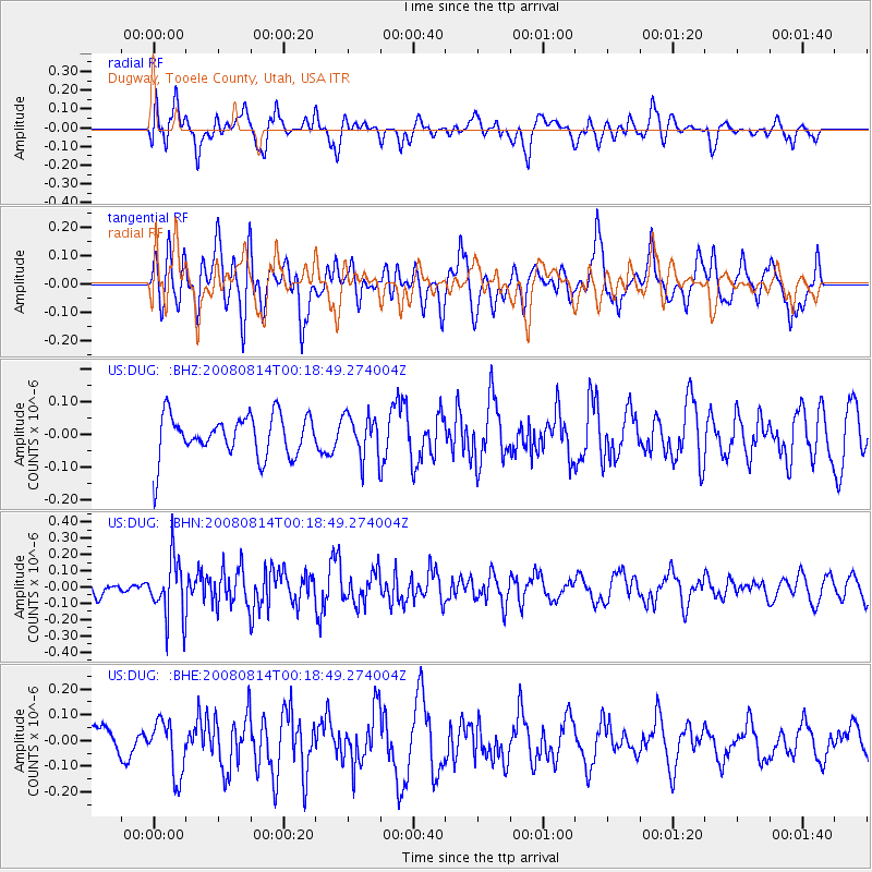
DUG Dugway, Tooele County, Utah, USA - Earthquake Result Viewer
*The percent match for this event was below the threshold and hence no stack was calculated.
| Earthquake location: |
Mariana Islands |
| Earthquake latitude/longitude: |
16.4/146.9 |
| Earthquake time(UTC): |
2008/08/14 (227) 00:06:40 GMT |
| Earthquake Depth: |
53 km |
| Earthquake Magnitude: |
5.5 MB, 4.8 MS |
| Earthquake Catalog/Contributor: |
WHDF/NEIC |
|
| Network: |
US United States National Seismic Network |
| Station: |
DUG Dugway, Tooele County, Utah, USA |
| Lat/Lon: |
40.19 N/112.81 W |
| Elevation: |
1477 m |
|
| Distance: |
87.1 deg |
| Az: |
48.998 deg |
| Baz: |
289.001 deg |
| Ray Param: |
$rayparam |
*The percent match for this event was below the threshold and hence was not used in the summary stack. |
|
| Radial Match: |
53.290554 % |
| Radial Bump: |
400 |
| Transverse Match: |
47.17724 % |
| Transverse Bump: |
400 |
| SOD ConfigId: |
2504 |
| Insert Time: |
2010-03-05 04:16:53.957 +0000 |
| GWidth: |
2.5 |
| Max Bumps: |
400 |
| Tol: |
0.001 |
|
Signal To Noise
| Channel | StoN | STA | LTA |
| US:DUG: :BHN:20080814T00:18:49.274004Z | 2.6702414 | 1.8145707E-7 | 6.7955305E-8 |
| US:DUG: :BHE:20080814T00:18:49.274004Z | 1.3623161 | 1.0519009E-7 | 7.721415E-8 |
| US:DUG: :BHZ:20080814T00:18:49.274004Z | 1.0108399 | 6.4908214E-8 | 6.421215E-8 |
| Arrivals |
| Ps | |
| PpPs | |
| PsPs/PpSs | |


