You are here: Home > Network List > CI - Caltech Regional Seismic Network Stations List
> Station MPM Manuel Prospect Mine, California, USA > Earthquake Result Viewer
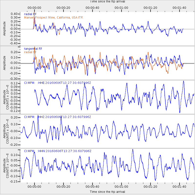
MPM Manuel Prospect Mine, California, USA - Earthquake Result Viewer
*The percent match for this event was below the threshold and hence no stack was calculated.
| Earthquake location: |
Near Coast Of Central Chile |
| Earthquake latitude/longitude: |
-30.1/-71.5 |
| Earthquake time(UTC): |
2016/06/06 (158) 13:16:02 GMT |
| Earthquake Depth: |
30 km |
| Earthquake Magnitude: |
5.5 MWW, 5.4 MWB |
| Earthquake Catalog/Contributor: |
NEIC PDE/NEIC COMCAT |
|
| Network: |
CI Caltech Regional Seismic Network |
| Station: |
MPM Manuel Prospect Mine, California, USA |
| Lat/Lon: |
36.06 N/117.49 W |
| Elevation: |
185 m |
|
| Distance: |
78.7 deg |
| Az: |
323.511 deg |
| Baz: |
140.485 deg |
| Ray Param: |
$rayparam |
*The percent match for this event was below the threshold and hence was not used in the summary stack. |
|
| Radial Match: |
43.17284 % |
| Radial Bump: |
398 |
| Transverse Match: |
58.68818 % |
| Transverse Bump: |
400 |
| SOD ConfigId: |
7422571 |
| Insert Time: |
2019-04-22 18:24:14.169 +0000 |
| GWidth: |
2.5 |
| Max Bumps: |
400 |
| Tol: |
0.001 |
|
Signal To Noise
| Channel | StoN | STA | LTA |
| CI:MPM: :HHZ:20160606T13:27:30.607996Z | 2.4941907 | 9.8550856E-8 | 3.9512155E-8 |
| CI:MPM: :HHN:20160606T13:27:30.607996Z | 1.4193506 | 7.262856E-8 | 5.1170268E-8 |
| CI:MPM: :HHE:20160606T13:27:30.607996Z | 1.5943627 | 6.6036606E-8 | 4.1418808E-8 |
| Arrivals |
| Ps | |
| PpPs | |
| PsPs/PpSs | |


