You are here: Home > Network List > US - United States National Seismic Network Stations List
> Station DUG Dugway, Tooele County, Utah, USA > Earthquake Result Viewer
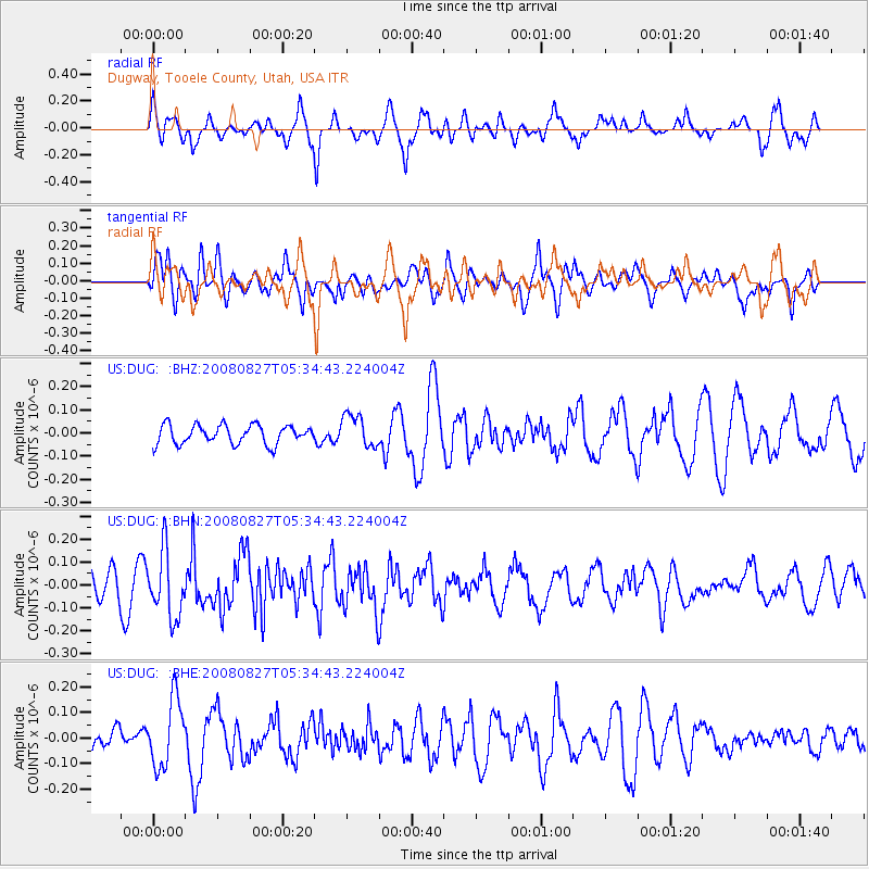
DUG Dugway, Tooele County, Utah, USA - Earthquake Result Viewer
*The percent match for this event was below the threshold and hence no stack was calculated.
| Earthquake location: |
Kuril Islands |
| Earthquake latitude/longitude: |
46.7/152.5 |
| Earthquake time(UTC): |
2008/08/27 (240) 05:24:41 GMT |
| Earthquake Depth: |
65 km |
| Earthquake Magnitude: |
5.5 MB, 5.4 MW, 5.3 MW |
| Earthquake Catalog/Contributor: |
WHDF/NEIC |
|
| Network: |
US United States National Seismic Network |
| Station: |
DUG Dugway, Tooele County, Utah, USA |
| Lat/Lon: |
40.19 N/112.81 W |
| Elevation: |
1477 m |
|
| Distance: |
65.0 deg |
| Az: |
57.421 deg |
| Baz: |
310.818 deg |
| Ray Param: |
$rayparam |
*The percent match for this event was below the threshold and hence was not used in the summary stack. |
|
| Radial Match: |
76.61499 % |
| Radial Bump: |
400 |
| Transverse Match: |
59.665993 % |
| Transverse Bump: |
400 |
| SOD ConfigId: |
2504 |
| Insert Time: |
2010-03-05 04:16:57.934 +0000 |
| GWidth: |
2.5 |
| Max Bumps: |
400 |
| Tol: |
0.001 |
|
Signal To Noise
| Channel | StoN | STA | LTA |
| US:DUG: :BHN:20080827T05:34:43.224004Z | 1.6753739 | 1.4265E-7 | 8.514517E-8 |
| US:DUG: :BHE:20080827T05:34:43.224004Z | 2.717627 | 1.3291869E-7 | 4.8909836E-8 |
| US:DUG: :BHZ:20080827T05:34:43.224004Z | 1.7210941 | 6.992725E-8 | 4.0629537E-8 |
| Arrivals |
| Ps | |
| PpPs | |
| PsPs/PpSs | |


