You are here: Home > Network List > CI - Caltech Regional Seismic Network Stations List
> Station SHO Shoshone, CA, USA > Earthquake Result Viewer
SHO Shoshone, CA, USA - Earthquake Result Viewer
| Earthquake location: |
North Of Severnaya Zemlya |
| Earthquake latitude/longitude: |
84.9/99.4 |
| Earthquake time(UTC): |
2005/03/06 (065) 05:21:43 GMT |
| Earthquake Depth: |
10 km |
| Earthquake Magnitude: |
6.1 MB, 6.1 MS, 6.2 MW, 6.2 MW |
| Earthquake Catalog/Contributor: |
WHDF/NEIC |
|
| Network: |
CI Caltech Regional Seismic Network |
| Station: |
SHO Shoshone, CA, USA |
| Lat/Lon: |
35.90 N/116.28 W |
| Elevation: |
451 m |
|
| Distance: |
58.5 deg |
| Az: |
33.739 deg |
| Baz: |
356.523 deg |
| Ray Param: |
0.062826365 |
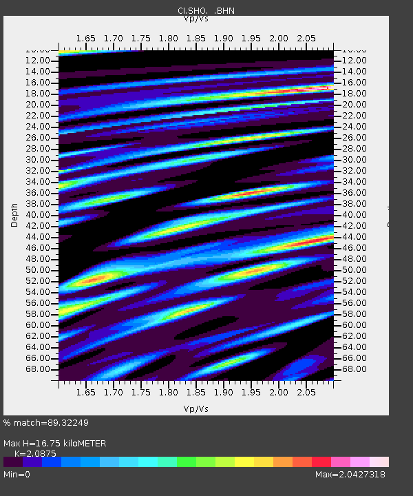
| Estimated Moho Depth: |
16.75 km |
| Estimated Crust Vp/Vs: |
2.09 |
| Assumed Crust Vp: |
6.276 km/s |
| Estimated Crust Vs: |
3.006 km/s |
| Estimated Crust Poisson's Ratio: |
0.35 |
|
| Radial Match: |
89.32249 % |
| Radial Bump: |
400 |
| Transverse Match: |
90.780205 % |
| Transverse Bump: |
400 |
| SOD ConfigId: |
2455 |
| Insert Time: |
2010-02-26 00:26:43.007 +0000 |
| GWidth: |
2.5 |
| Max Bumps: |
400 |
| Tol: |
0.001 |
|
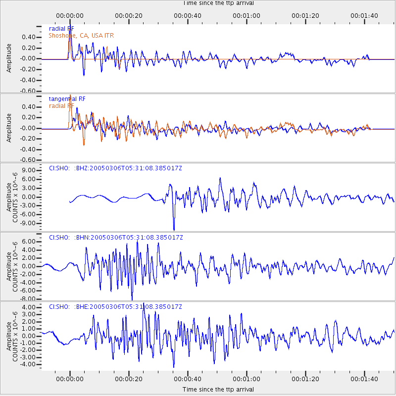
Signal To Noise
| Channel | StoN | STA | LTA |
| CI:SHO: :BHN:20050306T05:31:08.385017Z | 2.460309 | 1.461153E-6 | 5.9389004E-7 |
| CI:SHO: :BHE:20050306T05:31:08.385017Z | 1.1418037 | 6.285822E-7 | 5.5051686E-7 |
| CI:SHO: :BHZ:20050306T05:31:08.385017Z | 2.8209422 | 2.0147215E-6 | 7.1420163E-7 |
| Arrivals |
| Ps | 3.0 SECOND |
| PpPs | 7.9 SECOND |
| PsPs/PpSs | 11 SECOND |


