You are here: Home > Network List > TA - USArray Transportable Network (new EarthScope stations) Stations List
> Station T25A Trinidad, CO, USA > Earthquake Result Viewer
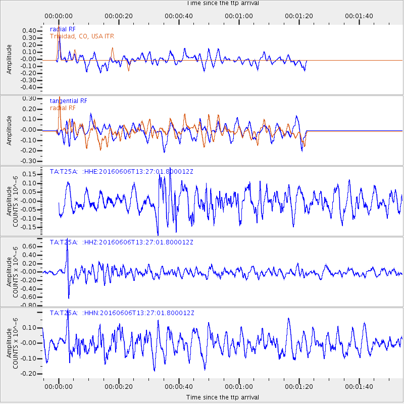
T25A Trinidad, CO, USA - Earthquake Result Viewer
*The percent match for this event was below the threshold and hence no stack was calculated.
| Earthquake location: |
Near Coast Of Central Chile |
| Earthquake latitude/longitude: |
-30.1/-71.5 |
| Earthquake time(UTC): |
2016/06/06 (158) 13:16:02 GMT |
| Earthquake Depth: |
30 km |
| Earthquake Magnitude: |
5.5 MWW, 5.4 MWB |
| Earthquake Catalog/Contributor: |
NEIC PDE/NEIC COMCAT |
|
| Network: |
TA USArray Transportable Network (new EarthScope stations) |
| Station: |
T25A Trinidad, CO, USA |
| Lat/Lon: |
37.14 N/104.41 W |
| Elevation: |
2017 m |
|
| Distance: |
73.6 deg |
| Az: |
333.062 deg |
| Baz: |
150.561 deg |
| Ray Param: |
$rayparam |
*The percent match for this event was below the threshold and hence was not used in the summary stack. |
|
| Radial Match: |
53.224705 % |
| Radial Bump: |
400 |
| Transverse Match: |
62.417183 % |
| Transverse Bump: |
361 |
| SOD ConfigId: |
7422571 |
| Insert Time: |
2019-04-22 18:29:31.885 +0000 |
| GWidth: |
2.5 |
| Max Bumps: |
400 |
| Tol: |
0.001 |
|
Signal To Noise
| Channel | StoN | STA | LTA |
| TA:T25A: :HHZ:20160606T13:27:01.800012Z | 4.287458 | 2.632393E-7 | 6.139752E-8 |
| TA:T25A: :HHN:20160606T13:27:01.800012Z | 1.1111648 | 7.312171E-8 | 6.5806354E-8 |
| TA:T25A: :HHE:20160606T13:27:01.800012Z | 1.8569692 | 8.069672E-8 | 4.3456144E-8 |
| Arrivals |
| Ps | |
| PpPs | |
| PsPs/PpSs | |


