You are here: Home > Network List > CI - Caltech Regional Seismic Network Stations List
> Station SHO Shoshone, CA, USA > Earthquake Result Viewer
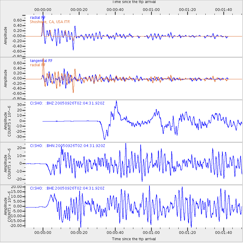
SHO Shoshone, CA, USA - Earthquake Result Viewer

| Earthquake location: |
Northern Peru |
| Earthquake latitude/longitude: |
-5.7/-76.4 |
| Earthquake time(UTC): |
2005/09/26 (269) 01:55:37 GMT |
| Earthquake Depth: |
115 km |
| Earthquake Magnitude: |
6.7 MB, 7.5 MW, 7.5 MW |
| Earthquake Catalog/Contributor: |
WHDF/NEIC |
|
| Network: |
CI Caltech Regional Seismic Network |
| Station: |
SHO Shoshone, CA, USA |
| Lat/Lon: |
35.90 N/116.28 W |
| Elevation: |
451 m |
|
| Distance: |
55.8 deg |
| Az: |
320.972 deg |
| Baz: |
129.482 deg |
| Ray Param: |
0.064229384 |
| Estimated Moho Depth: |
38.25 km |
| Estimated Crust Vp/Vs: |
2.07 |
| Assumed Crust Vp: |
6.276 km/s |
| Estimated Crust Vs: |
3.032 km/s |
| Estimated Crust Poisson's Ratio: |
0.35 |
|
| Radial Match: |
88.02826 % |
| Radial Bump: |
400 |
| Transverse Match: |
71.17741 % |
| Transverse Bump: |
400 |
| SOD ConfigId: |
2564 |
| Insert Time: |
2010-02-26 00:26:49.609 +0000 |
| GWidth: |
2.5 |
| Max Bumps: |
400 |
| Tol: |
0.001 |
|
Signal To Noise
| Channel | StoN | STA | LTA |
| CI:SHO: :BHN:20050926T02:04:31.920Z | 33.40962 | 6.078401E-6 | 1.8193566E-7 |
| CI:SHO: :BHE:20050926T02:04:31.920Z | 24.559744 | 5.36422E-6 | 2.1841514E-7 |
| CI:SHO: :BHZ:20050926T02:04:31.920Z | 55.797012 | 1.6625454E-5 | 2.9796317E-7 |
| Arrivals |
| Ps | 6.8 SECOND |
| PpPs | 18 SECOND |
| PsPs/PpSs | 25 SECOND |


