You are here: Home > Network List > US - United States National Seismic Network Stations List
> Station DUG Dugway, Tooele County, Utah, USA > Earthquake Result Viewer
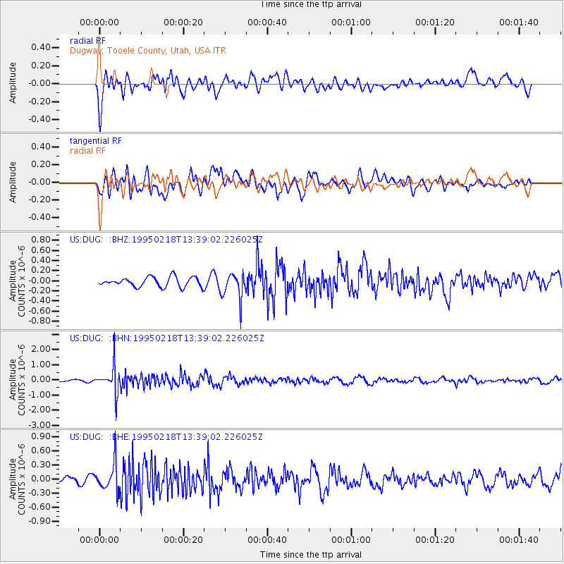
DUG Dugway, Tooele County, Utah, USA - Earthquake Result Viewer
*The percent match for this event was below the threshold and hence no stack was calculated.
| Earthquake location: |
Sea Of Okhotsk |
| Earthquake latitude/longitude: |
46.7/145.9 |
| Earthquake time(UTC): |
1995/02/18 (049) 13:29:06 GMT |
| Earthquake Depth: |
355 km |
| Earthquake Magnitude: |
5.6 MB, 5.7 UNKNOWN, 5.5 MW |
| Earthquake Catalog/Contributor: |
WHDF/NEIC |
|
| Network: |
US United States National Seismic Network |
| Station: |
DUG Dugway, Tooele County, Utah, USA |
| Lat/Lon: |
40.19 N/112.81 W |
| Elevation: |
1477 m |
|
| Distance: |
68.7 deg |
| Az: |
53.715 deg |
| Baz: |
313.554 deg |
| Ray Param: |
$rayparam |
*The percent match for this event was below the threshold and hence was not used in the summary stack. |
|
| Radial Match: |
54.021244 % |
| Radial Bump: |
400 |
| Transverse Match: |
62.97345 % |
| Transverse Bump: |
400 |
| SOD ConfigId: |
4480 |
| Insert Time: |
2010-03-05 04:18:43.931 +0000 |
| GWidth: |
2.5 |
| Max Bumps: |
400 |
| Tol: |
0.001 |
|
Signal To Noise
| Channel | StoN | STA | LTA |
| US:DUG: :BHN:19950218T13:39:02.226025Z | 9.4042635 | 8.8744594E-7 | 9.436634E-8 |
| US:DUG: :BHE:19950218T13:39:02.226025Z | 5.007216 | 2.9722509E-7 | 5.935935E-8 |
| US:DUG: :BHZ:19950218T13:39:02.226025Z | 2.6071765 | 2.504768E-7 | 9.607206E-8 |
| Arrivals |
| Ps | |
| PpPs | |
| PsPs/PpSs | |


