You are here: Home > Network List > US - United States National Seismic Network Stations List
> Station WVOR Wild Horse Valley, Oregon, USA > Earthquake Result Viewer
WVOR Wild Horse Valley, Oregon, USA - Earthquake Result Viewer
| Earthquake location: |
Off Coast Of Costa Rica |
| Earthquake latitude/longitude: |
9.4/-85.3 |
| Earthquake time(UTC): |
2000/07/21 (203) 01:53:35 GMT |
| Earthquake Depth: |
33 km |
| Earthquake Magnitude: |
5.9 MB, 6.1 MS, 6.4 MW, 5.7 ML |
| Earthquake Catalog/Contributor: |
WHDF/NEIC |
|
| Network: |
US United States National Seismic Network |
| Station: |
WVOR Wild Horse Valley, Oregon, USA |
| Lat/Lon: |
42.43 N/118.64 W |
| Elevation: |
1344 m |
|
| Distance: |
44.0 deg |
| Az: |
324.157 deg |
| Baz: |
128.697 deg |
| Ray Param: |
0.07214227 |
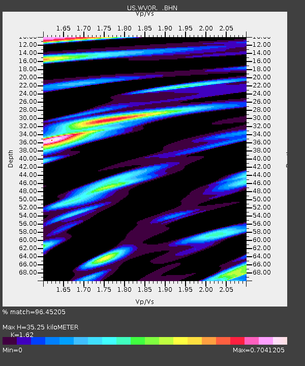
| Estimated Moho Depth: |
35.25 km |
| Estimated Crust Vp/Vs: |
1.62 |
| Assumed Crust Vp: |
6.279 km/s |
| Estimated Crust Vs: |
3.876 km/s |
| Estimated Crust Poisson's Ratio: |
0.19 |
|
| Radial Match: |
96.45205 % |
| Radial Bump: |
400 |
| Transverse Match: |
96.70979 % |
| Transverse Bump: |
400 |
| SOD ConfigId: |
110165 |
| Insert Time: |
2010-03-05 04:19:03.219 +0000 |
| GWidth: |
2.5 |
| Max Bumps: |
400 |
| Tol: |
0.001 |
|
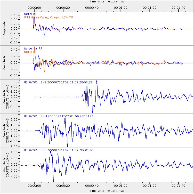
Signal To Noise
| Channel | StoN | STA | LTA |
| US:WVOR: :BHN:20000721T02:01:09.286013Z | 2.5850992 | 1.2176221E-7 | 4.710156E-8 |
| US:WVOR: :BHE:20000721T02:01:09.286013Z | 2.7964134 | 1.8730711E-7 | 6.6981194E-8 |
| US:WVOR: :BHZ:20000721T02:01:09.286013Z | 12.284882 | 7.760048E-7 | 6.316746E-8 |
| Arrivals |
| Ps | 3.7 SECOND |
| PpPs | 14 SECOND |
| PsPs/PpSs | 17 SECOND |


