You are here: Home > Network List > US - United States National Seismic Network Stations List
> Station WVOR Wild Horse Valley, Oregon, USA > Earthquake Result Viewer
WVOR Wild Horse Valley, Oregon, USA - Earthquake Result Viewer
| Earthquake location: |
Central East Pacific Rise |
| Earthquake latitude/longitude: |
-4.1/-104.5 |
| Earthquake time(UTC): |
2001/06/26 (177) 12:33:52 GMT |
| Earthquake Depth: |
10 km |
| Earthquake Magnitude: |
5.0 MB, 5.8 MS, 6.0 MW, 6.0 MW |
| Earthquake Catalog/Contributor: |
WHDF/NEIC |
|
| Network: |
US United States National Seismic Network |
| Station: |
WVOR Wild Horse Valley, Oregon, USA |
| Lat/Lon: |
42.43 N/118.64 W |
| Elevation: |
1344 m |
|
| Distance: |
48.0 deg |
| Az: |
345.897 deg |
| Baz: |
160.832 deg |
| Ray Param: |
0.06961104 |
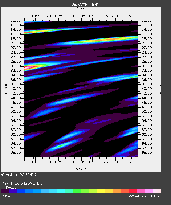
| Estimated Moho Depth: |
30.5 km |
| Estimated Crust Vp/Vs: |
1.60 |
| Assumed Crust Vp: |
6.279 km/s |
| Estimated Crust Vs: |
3.924 km/s |
| Estimated Crust Poisson's Ratio: |
0.18 |
|
| Radial Match: |
93.51417 % |
| Radial Bump: |
379 |
| Transverse Match: |
82.357834 % |
| Transverse Bump: |
400 |
| SOD ConfigId: |
110165 |
| Insert Time: |
2010-03-05 04:19:43.367 +0000 |
| GWidth: |
2.5 |
| Max Bumps: |
400 |
| Tol: |
0.001 |
|
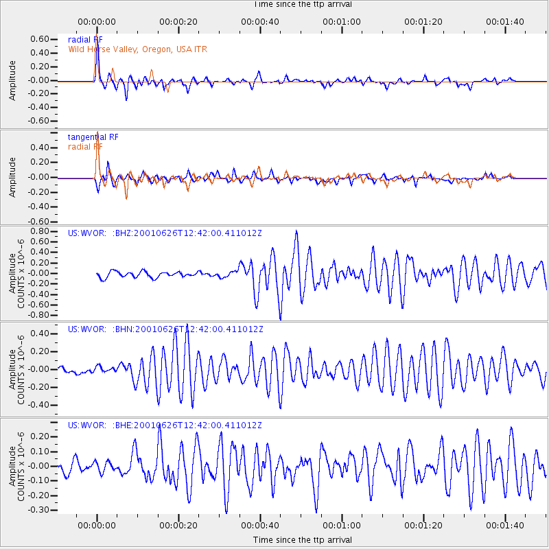
Signal To Noise
| Channel | StoN | STA | LTA |
| US:WVOR: :BHN:20010626T12:42:00.411012Z | 0.9118484 | 3.3232826E-8 | 3.644556E-8 |
| US:WVOR: :BHE:20010626T12:42:00.411012Z | 0.6139595 | 3.5793967E-8 | 5.830021E-8 |
| US:WVOR: :BHZ:20010626T12:42:00.411012Z | 1.0917491 | 6.0086776E-8 | 5.5037162E-8 |
| Arrivals |
| Ps | 3.1 SECOND |
| PpPs | 12 SECOND |
| PsPs/PpSs | 15 SECOND |


