You are here: Home > Network List > AZ - ANZA Regional Network Stations List
> Station SMER AZ.SMER > Earthquake Result Viewer
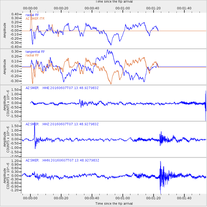
SMER AZ.SMER - Earthquake Result Viewer
*The percent match for this event was below the threshold and hence no stack was calculated.
| Earthquake location: |
South Of Fiji Islands |
| Earthquake latitude/longitude: |
-23.7/-179.9 |
| Earthquake time(UTC): |
2016/06/07 (159) 07:02:52 GMT |
| Earthquake Depth: |
523 km |
| Earthquake Magnitude: |
5.5 MB |
| Earthquake Catalog/Contributor: |
NEIC PDE/NEIC COMCAT |
|
| Network: |
AZ ANZA Regional Network |
| Station: |
SMER AZ.SMER |
| Lat/Lon: |
33.46 N/117.17 W |
| Elevation: |
355 m |
|
| Distance: |
82.4 deg |
| Az: |
48.538 deg |
| Baz: |
235.284 deg |
| Ray Param: |
$rayparam |
*The percent match for this event was below the threshold and hence was not used in the summary stack. |
|
| Radial Match: |
51.483635 % |
| Radial Bump: |
400 |
| Transverse Match: |
48.59627 % |
| Transverse Bump: |
400 |
| SOD ConfigId: |
7422571 |
| Insert Time: |
2019-04-22 18:46:13.737 +0000 |
| GWidth: |
2.5 |
| Max Bumps: |
400 |
| Tol: |
0.001 |
|
Signal To Noise
| Channel | StoN | STA | LTA |
| AZ:SMER: :HHZ:20160607T07:13:48.927983Z | 9.980699 | 4.9626243E-7 | 4.9722214E-8 |
| AZ:SMER: :HHN:20160607T07:13:48.927983Z | 1.6192203 | 1.4988655E-7 | 9.256711E-8 |
| AZ:SMER: :HHE:20160607T07:13:48.927983Z | 2.20113 | 1.6822987E-7 | 7.642887E-8 |
| Arrivals |
| Ps | |
| PpPs | |
| PsPs/PpSs | |


