You are here: Home > Network List > US - United States National Seismic Network Stations List
> Station WVOR Wild Horse Valley, Oregon, USA > Earthquake Result Viewer
WVOR Wild Horse Valley, Oregon, USA - Earthquake Result Viewer
| Earthquake location: |
Near Coast Of Guatemala |
| Earthquake latitude/longitude: |
13.7/-91.2 |
| Earthquake time(UTC): |
2002/11/09 (313) 00:14:18 GMT |
| Earthquake Depth: |
33 km |
| Earthquake Magnitude: |
5.4 MB, 5.6 MS, 6.0 MW, 5.9 MW |
| Earthquake Catalog/Contributor: |
WHDF/NEIC |
|
| Network: |
US United States National Seismic Network |
| Station: |
WVOR Wild Horse Valley, Oregon, USA |
| Lat/Lon: |
42.43 N/118.64 W |
| Elevation: |
1344 m |
|
| Distance: |
37.1 deg |
| Az: |
325.588 deg |
| Baz: |
132.115 deg |
| Ray Param: |
0.07623363 |
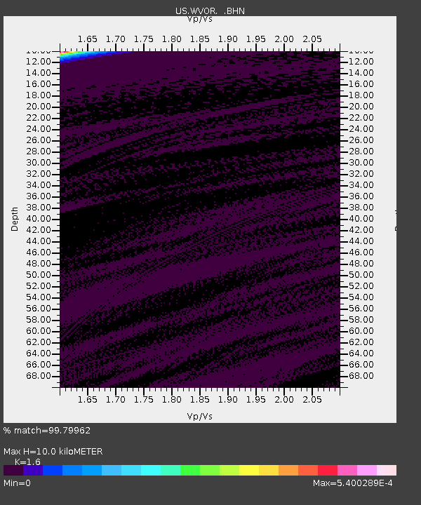
| Estimated Moho Depth: |
10.0 km |
| Estimated Crust Vp/Vs: |
1.60 |
| Assumed Crust Vp: |
6.279 km/s |
| Estimated Crust Vs: |
3.924 km/s |
| Estimated Crust Poisson's Ratio: |
0.18 |
|
| Radial Match: |
99.79962 % |
| Radial Bump: |
23 |
| Transverse Match: |
99.70058 % |
| Transverse Bump: |
25 |
| SOD ConfigId: |
110165 |
| Insert Time: |
2010-03-05 04:20:03.063 +0000 |
| GWidth: |
2.5 |
| Max Bumps: |
400 |
| Tol: |
0.001 |
|
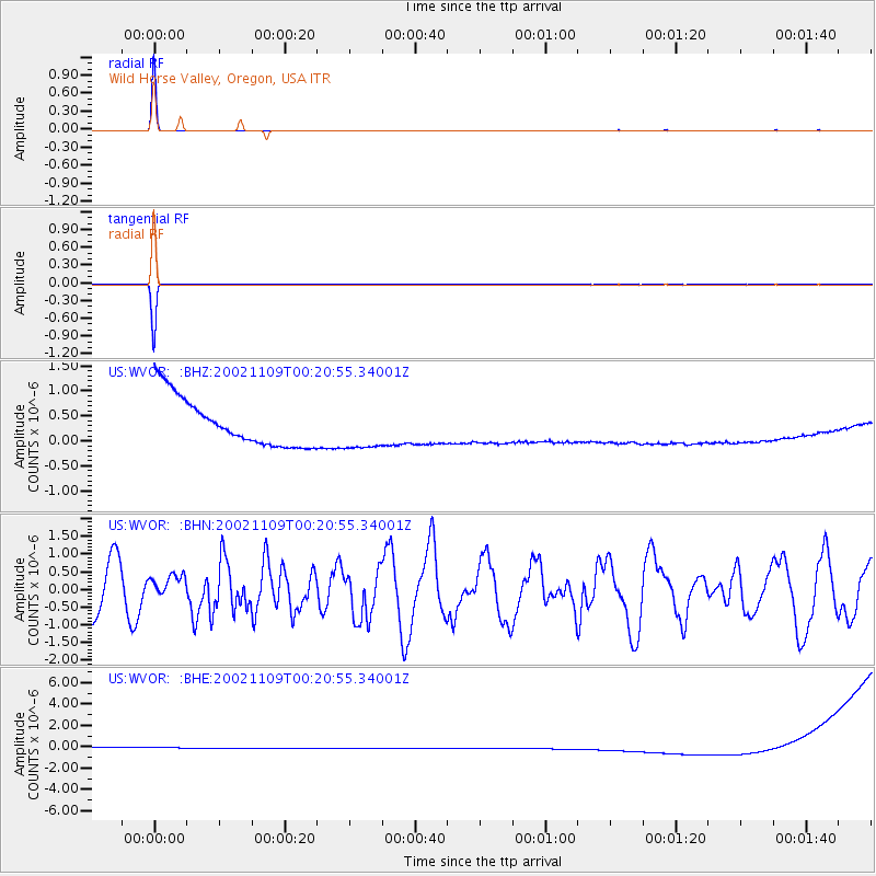
Signal To Noise
| Channel | StoN | STA | LTA |
| US:WVOR: :BHN:20021109T00:20:55.34001Z | 0.46211773 | 3.1171155E-7 | 6.745284E-7 |
| US:WVOR: :BHE:20021109T00:20:55.34001Z | 0.9108271 | 5.2922854E-7 | 5.810417E-7 |
| US:WVOR: :BHZ:20021109T00:20:55.34001Z | 0.9109618 | 4.4068264E-7 | 4.8375534E-7 |
| Arrivals |
| Ps | 1.0 SECOND |
| PpPs | 3.8 SECOND |
| PsPs/PpSs | 4.9 SECOND |


