You are here: Home > Network List > US - United States National Seismic Network Stations List
> Station WVOR Wild Horse Valley, Oregon, USA > Earthquake Result Viewer
WVOR Wild Horse Valley, Oregon, USA - Earthquake Result Viewer
| Earthquake location: |
Solomon Islands |
| Earthquake latitude/longitude: |
-11.0/161.4 |
| Earthquake time(UTC): |
2002/10/03 (276) 04:26:06 GMT |
| Earthquake Depth: |
10 km |
| Earthquake Magnitude: |
5.6 MB, 5.6 MS, 5.9 MW, 5.7 MW |
| Earthquake Catalog/Contributor: |
WHDF/NEIC |
|
| Network: |
US United States National Seismic Network |
| Station: |
WVOR Wild Horse Valley, Oregon, USA |
| Lat/Lon: |
42.43 N/118.64 W |
| Elevation: |
1344 m |
|
| Distance: |
90.0 deg |
| Az: |
46.791 deg |
| Baz: |
255.18 deg |
| Ray Param: |
0.041704714 |
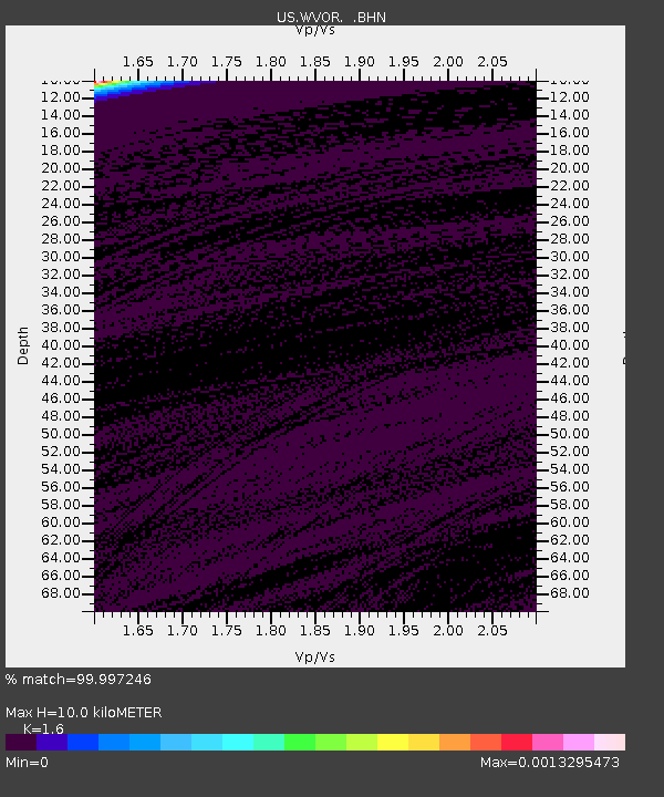
| Estimated Moho Depth: |
10.0 km |
| Estimated Crust Vp/Vs: |
1.60 |
| Assumed Crust Vp: |
6.279 km/s |
| Estimated Crust Vs: |
3.924 km/s |
| Estimated Crust Poisson's Ratio: |
0.18 |
|
| Radial Match: |
99.997246 % |
| Radial Bump: |
2 |
| Transverse Match: |
99.92264 % |
| Transverse Bump: |
5 |
| SOD ConfigId: |
110165 |
| Insert Time: |
2010-03-05 04:20:05.936 +0000 |
| GWidth: |
2.5 |
| Max Bumps: |
400 |
| Tol: |
0.001 |
|
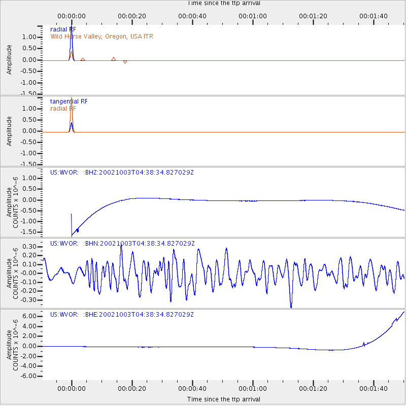
Signal To Noise
| Channel | StoN | STA | LTA |
| US:WVOR: :BHN:20021003T04:38:34.827029Z | 0.7782433 | 5.7686663E-8 | 7.41242E-8 |
| US:WVOR: :BHE:20021003T04:38:34.827029Z | 0.9293511 | 5.323274E-7 | 5.7279476E-7 |
| US:WVOR: :BHZ:20021003T04:38:34.827029Z | 0.9023284 | 4.6727084E-7 | 5.1785014E-7 |
| Arrivals |
| Ps | 1.0 SECOND |
| PpPs | 4.1 SECOND |
| PsPs/PpSs | 5.0 SECOND |


