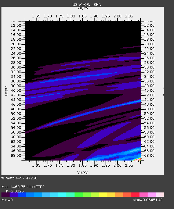
WVOR Wild Horse Valley, Oregon, USA - Earthquake Result Viewer
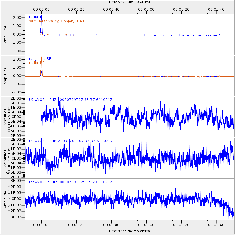
Earthquake location: Near N Coast Of New Guinea, P.N.G.
Earthquake latitude/longitude: -4.9/145.2
Earthquake time(UTC): 2003/07/09 (190) 07:22:39 GMT
Earthquake Depth: 53 km
Earthquake Magnitude: 5.4 MB, 5.0 MS, 5.6 MW, 5.5 MW
Earthquake Catalog/Contributor: WHDF/NEIC
Network: US United States National Seismic Network
Station: WVOR Wild Horse Valley, Oregon, USA
Lat/Lon: 42.43 N/118.64 W
Elevation: 1344 m
Distance: 97.8 deg
Az: 47.987 deg
Baz: 270.485 deg
Ray Param: 0.040059086
Estimated Moho Depth: 69.75 km
Estimated Crust Vp/Vs: 2.08
Assumed Crust Vp: 6.279 km/s
Estimated Crust Vs: 3.015 km/s
Estimated Crust Poisson's Ratio: 0.35
Radial Match: 97.47258 %
Radial Bump: 85
Transverse Match: 92.912224 %
Transverse Bump: 145
SOD ConfigId: 110165
Insert Time: 2010-03-05 04:20:31.233 +0000
GWidth: 2.5
Max Bumps: 400
Tol: 0.001

Signal To Noise

ChannelStoNSTALTA
US:WVOR: :BHN:20030709T07:35:37.611021Z1.31551596.643425E-105.050053E-10
US:WVOR: :BHE:20030709T07:35:37.611021Z0.992786945.4034127E-105.4426713E-10
US:WVOR: :BHZ:20030709T07:35:37.611021Z1.00271715.795602E-105.779897E-10
Arrivals
Ps12 SECOND
PpPs34 SECOND
PsPs/PpSs46 SECOND