You are here: Home > Network List > TA - USArray Transportable Network (new EarthScope stations) Stations List
> Station 833A Chaparral WMA, Artesia Wells, TX, USA > Earthquake Result Viewer
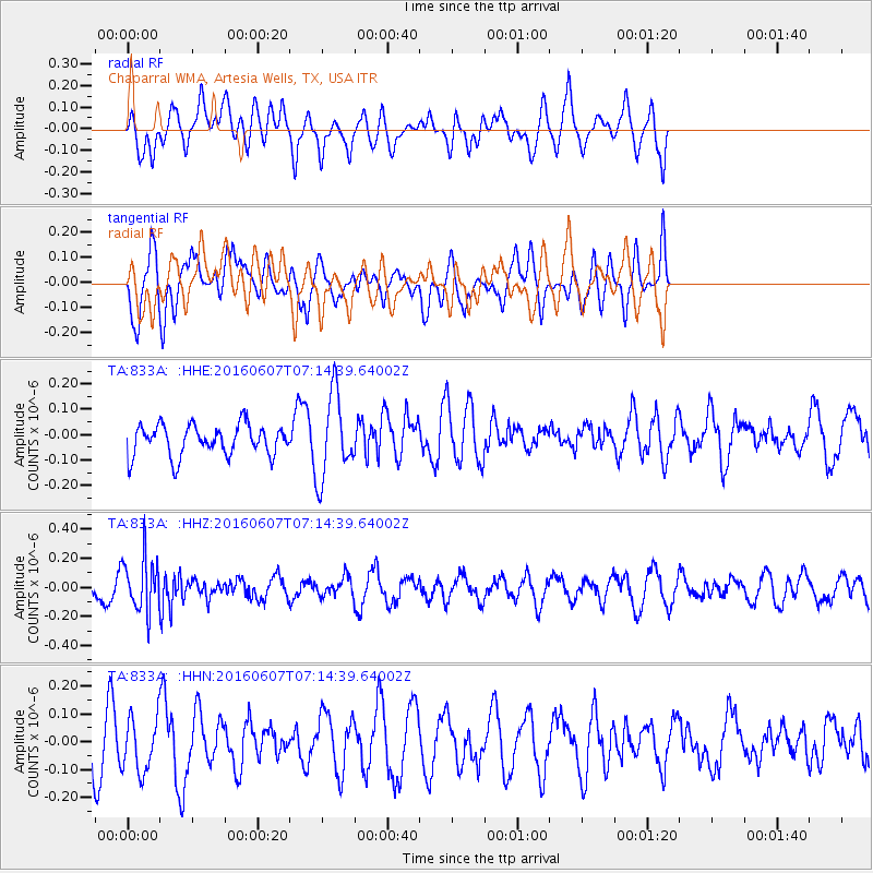
833A Chaparral WMA, Artesia Wells, TX, USA - Earthquake Result Viewer
*The percent match for this event was below the threshold and hence no stack was calculated.
| Earthquake location: |
South Of Fiji Islands |
| Earthquake latitude/longitude: |
-23.7/-179.9 |
| Earthquake time(UTC): |
2016/06/07 (159) 07:02:52 GMT |
| Earthquake Depth: |
523 km |
| Earthquake Magnitude: |
5.5 MB |
| Earthquake Catalog/Contributor: |
NEIC PDE/NEIC COMCAT |
|
| Network: |
TA USArray Transportable Network (new EarthScope stations) |
| Station: |
833A Chaparral WMA, Artesia Wells, TX, USA |
| Lat/Lon: |
28.32 N/99.39 W |
| Elevation: |
171 m |
|
| Distance: |
93.1 deg |
| Az: |
60.539 deg |
| Baz: |
244.907 deg |
| Ray Param: |
$rayparam |
*The percent match for this event was below the threshold and hence was not used in the summary stack. |
|
| Radial Match: |
42.95154 % |
| Radial Bump: |
400 |
| Transverse Match: |
43.194477 % |
| Transverse Bump: |
373 |
| SOD ConfigId: |
7422571 |
| Insert Time: |
2019-04-22 18:49:47.106 +0000 |
| GWidth: |
2.5 |
| Max Bumps: |
400 |
| Tol: |
0.001 |
|
Signal To Noise
| Channel | StoN | STA | LTA |
| TA:833A: :HHZ:20160607T07:14:39.64002Z | 1.7311921 | 1.8412868E-7 | 1.0635947E-7 |
| TA:833A: :HHN:20160607T07:14:39.64002Z | 0.9456015 | 9.782925E-8 | 1.0345716E-7 |
| TA:833A: :HHE:20160607T07:14:39.64002Z | 2.7265944 | 1.6785931E-7 | 6.1563725E-8 |
| Arrivals |
| Ps | |
| PpPs | |
| PsPs/PpSs | |


