You are here: Home > Network List > TA - USArray Transportable Network (new EarthScope stations) Stations List
> Station G05D Wamic, OR, USA > Earthquake Result Viewer
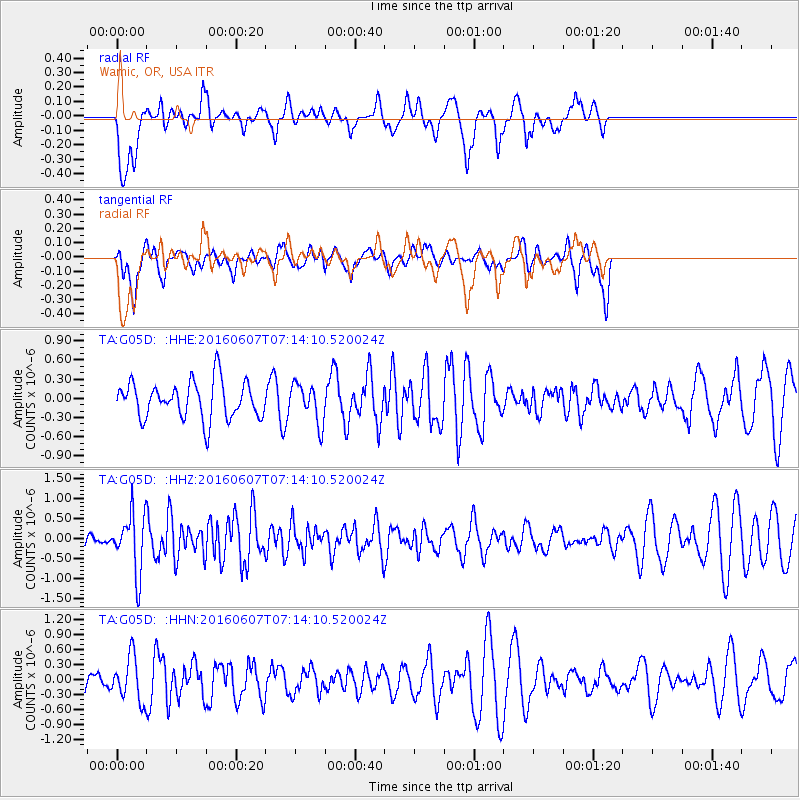
G05D Wamic, OR, USA - Earthquake Result Viewer
*The percent match for this event was below the threshold and hence no stack was calculated.
| Earthquake location: |
South Of Fiji Islands |
| Earthquake latitude/longitude: |
-23.7/-179.9 |
| Earthquake time(UTC): |
2016/06/07 (159) 07:02:52 GMT |
| Earthquake Depth: |
523 km |
| Earthquake Magnitude: |
5.5 MB |
| Earthquake Catalog/Contributor: |
NEIC PDE/NEIC COMCAT |
|
| Network: |
TA USArray Transportable Network (new EarthScope stations) |
| Station: |
G05D Wamic, OR, USA |
| Lat/Lon: |
45.24 N/121.32 W |
| Elevation: |
592 m |
|
| Distance: |
86.8 deg |
| Az: |
37.124 deg |
| Baz: |
231.569 deg |
| Ray Param: |
$rayparam |
*The percent match for this event was below the threshold and hence was not used in the summary stack. |
|
| Radial Match: |
73.640366 % |
| Radial Bump: |
400 |
| Transverse Match: |
44.163612 % |
| Transverse Bump: |
400 |
| SOD ConfigId: |
7422571 |
| Insert Time: |
2019-04-22 18:49:52.946 +0000 |
| GWidth: |
2.5 |
| Max Bumps: |
400 |
| Tol: |
0.001 |
|
Signal To Noise
| Channel | StoN | STA | LTA |
| TA:G05D: :HHZ:20160607T07:14:10.520024Z | 3.4768322 | 7.274968E-7 | 2.0924128E-7 |
| TA:G05D: :HHN:20160607T07:14:10.520024Z | 1.3120334 | 4.415444E-7 | 3.365344E-7 |
| TA:G05D: :HHE:20160607T07:14:10.520024Z | 0.94071776 | 2.7393858E-7 | 2.9120167E-7 |
| Arrivals |
| Ps | |
| PpPs | |
| PsPs/PpSs | |


