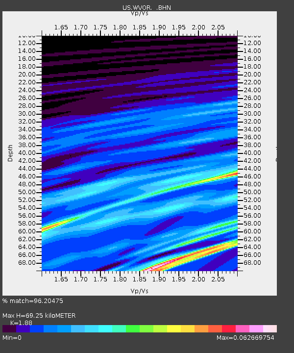
WVOR Wild Horse Valley, Oregon, USA - Earthquake Result Viewer

Earthquake location: New Britain Region, P.N.G.
Earthquake latitude/longitude: -5.5/151.7
Earthquake time(UTC): 2003/07/04 (185) 00:33:50 GMT
Earthquake Depth: 10 km
Earthquake Magnitude: 5.4 MB, 5.9 MS, 6.0 MW, 5.9 MW
Earthquake Catalog/Contributor: WHDF/NEIC
Network: US United States National Seismic Network
Station: WVOR Wild Horse Valley, Oregon, USA
Lat/Lon: 42.43 N/118.64 W
Elevation: 1344 m
Distance: 93.4 deg
Az: 47.869 deg
Baz: 265.751 deg
Ray Param: 0.04126629
Estimated Moho Depth: 69.25 km
Estimated Crust Vp/Vs: 1.88
Assumed Crust Vp: 6.279 km/s
Estimated Crust Vs: 3.34 km/s
Estimated Crust Poisson's Ratio: 0.30
Radial Match: 96.20475 %
Radial Bump: 134
Transverse Match: 95.29693 %
Transverse Bump: 95
SOD ConfigId: 110165
Insert Time: 2010-03-05 04:20:33.197 +0000
GWidth: 2.5
Max Bumps: 400
Tol: 0.001

Signal To Noise

ChannelStoNSTALTA
US:WVOR: :BHN:20030704T00:46:33.787009Z0.73497924.843766E-106.5903444E-10
US:WVOR: :BHE:20030704T00:46:33.787009Z1.15892217.6163326E-106.571911E-10
US:WVOR: :BHZ:20030704T00:46:33.787009Z0.73843755.7286587E-107.757811E-10
Arrivals
Ps9.9 SECOND
PpPs31 SECOND
PsPs/PpSs41 SECOND