You are here: Home > Network List > TA - USArray Transportable Network (new EarthScope stations) Stations List
> Station J26L Joseph Creek, AK, USA > Earthquake Result Viewer
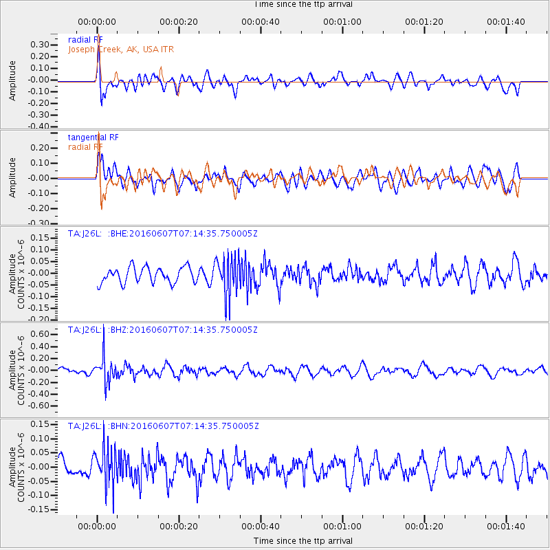
J26L Joseph Creek, AK, USA - Earthquake Result Viewer
*The percent match for this event was below the threshold and hence no stack was calculated.
| Earthquake location: |
South Of Fiji Islands |
| Earthquake latitude/longitude: |
-23.7/-179.9 |
| Earthquake time(UTC): |
2016/06/07 (159) 07:02:52 GMT |
| Earthquake Depth: |
523 km |
| Earthquake Magnitude: |
5.5 MB |
| Earthquake Catalog/Contributor: |
NEIC PDE/NEIC COMCAT |
|
| Network: |
TA USArray Transportable Network (new EarthScope stations) |
| Station: |
J26L Joseph Creek, AK, USA |
| Lat/Lon: |
64.50 N/143.56 W |
| Elevation: |
1144 m |
|
| Distance: |
92.3 deg |
| Az: |
14.855 deg |
| Baz: |
212.896 deg |
| Ray Param: |
$rayparam |
*The percent match for this event was below the threshold and hence was not used in the summary stack. |
|
| Radial Match: |
54.224346 % |
| Radial Bump: |
400 |
| Transverse Match: |
58.359726 % |
| Transverse Bump: |
400 |
| SOD ConfigId: |
7422571 |
| Insert Time: |
2019-04-22 18:50:02.329 +0000 |
| GWidth: |
2.5 |
| Max Bumps: |
400 |
| Tol: |
0.001 |
|
Signal To Noise
| Channel | StoN | STA | LTA |
| TA:J26L: :BHZ:20160607T07:14:35.750005Z | 3.467405 | 2.1712555E-7 | 6.261903E-8 |
| TA:J26L: :BHN:20160607T07:14:35.750005Z | 1.6257342 | 6.4639885E-8 | 3.9760426E-8 |
| TA:J26L: :BHE:20160607T07:14:35.750005Z | 2.4299092 | 8.067535E-8 | 3.3200973E-8 |
| Arrivals |
| Ps | |
| PpPs | |
| PsPs/PpSs | |


